1970s Maps of Hampshire County, West Virginia
Explore 13 historic maps of Hampshire County from the 1970s. These maps offer a rare glimpse into what life looked like during the 1970s — showing old roads, neighborhoods, homes, and landmarks that have changed or disappeared over time.
Whether you're researching your family's past, planning a metal detecting trip, or studying how Hampshire County's landscape evolved across the 1970s, these high-resolution maps are a powerful tool for exploring the history of this region.
- Focus on a specific era: All maps on this page are from the 1970s, giving you a focused view of this time period.
- See what’s changed: Compare century-old streets, trails, and buildings to today's modern landscape using overlays and satellite layers.
- Research with precision: Use these maps for genealogy, historical research, land use analysis, or educational projects.
- View, download, or print: Maps are fully viewable online in high resolution, and can be downloaded or printed for your own records.
Start exploring Hampshire County's history through authentic maps from the 1970s. This is your window into the past.
Hampshire County, WV maps
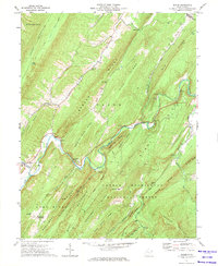
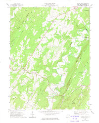
(13)- 1970 Map of Rio
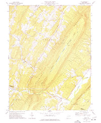 1970 Rio1970 Print · USGSHampshire County is shown in the early seventies, capturing the remote ridge-and-valley communities before modern development. Genealogists can trace family footprints at Hotts Chapel Cem, Mountaindale Sch, and the small settlement of Kirby.2 unique versions available
 - 1970 Map of Old Fields, 1973 Print
 1970 Old Fields1973 Print · USGSHardy and Hampshire counties come into focus during the early 1970s, showcasing a landscape of river-valley settlements and mountain gaps. Genealogists and historians can trace family locations near Purgitsville, Old Fields, and rural landmarks like Old Pine Ch.
 - 1970 Map of Yellow Spring, 1974 Print
 1970 Yellow Spring1974 Print · USGSHampshire County is shown here in the early 1970s, defined by the parallel ridges of the Appalachian Mountains and the winding Cacapon River. Researchers can trace the path of the Old Railroad Grade or locate early rural centers like Yellow Spring and Hebron Ch.
 - 1971 Map of Sector, 1973 Print
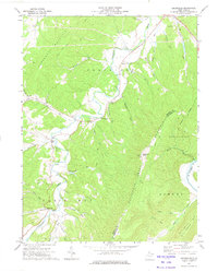
 1971 Sector1973 Print · USGSThe South Branch Potomac River valley in the early 1970s is shown here as a landscape of steep ridges and riverside rail. Genealogists and hikers can trace the paths near Sector, find St Lukes Ch, and follow the Baltimore and Ohio railroad through The Trough.
 - 1971 Map of Baker, 1974 Print
 1971 Baker1974 Print · USGSHardy County's ridge-and-valley landscape is documented here in the early seventies, centered on the unique hydrologic path of the Lost River. Researchers can locate family landmarks like the Baughman Settlement, Mt Moriah Ch, and the Old Iron Furnace.
 - 1972 Map of Burlington, 1975 Print
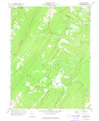
 1972 Burlington1975 Print · USGSMineral and Hampshire counties are shown here in the early seventies, centered on the Patterson Creek valley and the village of Burlington. Genealogists and local historians can trace rural landmarks like Kelley Chapel, Ridgeville, and Markwood Ch.2 unique versions available
 - 1973 Map of Largent, 1975 Print
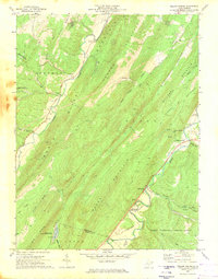
 1973 Largent1975 Print · USGSHampshire and Morgan counties are shown in the early seventies, where the Cacapon River winds through the sharp ridges of Sideling Hill. Genealogists and historians can locate rural landmarks like Island Hill Ch and the 19th-century Iron Ore Furnace at Bloomery.2 unique versions available
 - 1973 Map of Levels, 1975 Print
 1973 Levels1975 Print · USGSHampshire County ridge country is captured here in the early 1970s as agricultural life centered on the river bends. Genealogists and researchers can locate the Cornwell Sch, Spring Gap Ch, and family-named hollows near Levels and Points.
 - 1973 Map of Hanging Rock, 1975 Print
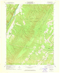
 1973 Hanging Rock1975 Print · USGSHampshire County ridge-and-valley life in the early 1970s is captured here as small crossroads communities like Slanesville and Pleasantdale dot the highlands. Researchers can trace historic church sites at Tear Coat Ch and mountain landmarks from Bens Knob to the bends of the Cacapon River.
 - 1973 Map of Springfield, 1975 Print
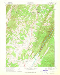
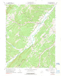
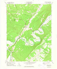 1973 Springfield1975 Print · USGSThe South Branch Potomac River meanders in dramatic loops through Hampshire County in the early seventies, carving deep into the Appalachian ridges. Genealogists and local historians can trace the Baltimore and Ohio rail line through Springfield or locate family sites near Three Churches and Millesons Mill.2 unique versions available
 - 1973 Map of Augusta, 1975 Print
 1973 Augusta1975 Print · USGSHampshire County’s high ridges and river valleys are captured here in the early seventies, showing a rural landscape shaped by the Cacapon River and Stony Mountain. Genealogists and historians can trace family locations near Augusta, Barnes Mill, and several community landmarks like Ebenezer Ch.2 unique versions available
 - 1973 Map of Headsville, 1975 Print
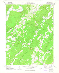
 1973 Headsville1975 Print · USGSThe Mineral and Hampshire county borderlands are captured here in the early 1970s as agricultural life follows the bends of Patterson Creek. Genealogists and local historians can locate rural landmarks like Reeses Mill, Eusebia Ch, and the high peak at Slate Lick Knob.
 - 1973 Map of Romney, 1975 Print
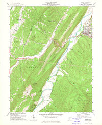 1973 Romney1975 Print · USGSHampshire and Mineral counties in the 1970s show a landscape of sharp ridges and deep river valleys during a period of steady rural development. Genealogists and historians can trace rail-side hamlets like Pancake and Mechanicsburg or locate rural landmarks such as Beaver Run Ch and Trinity Ch.2 unique versions available
End of results
Showing maps 1-13 of 13
Top cities of Hampshire County
Frequently asked questions
- What are the different types of historical maps available for Hampshire County?
- What is the oldest map of Hampshire County?
- Where can I purchase historical maps of Hampshire County for my home or office?
- Where can I download high-res historical maps of Hampshire County?
- Are there historical topographic maps available for Hampshire County?
- Is there historical aerial imagery available for Hampshire County?
- Where are historical maps of Hampshire County sourced from?