1950s Maps of Hampshire County, West Virginia
Explore 8 historic maps of Hampshire County from the 1950s. These maps offer a rare glimpse into what life looked like during the 1950s — showing old roads, neighborhoods, homes, and landmarks that have changed or disappeared over time.
Whether you're researching your family's past, planning a metal detecting trip, or studying how Hampshire County's landscape evolved across the 1950s, these high-resolution maps are a powerful tool for exploring the history of this region.
- Focus on a specific era: All maps on this page are from the 1950s, giving you a focused view of this time period.
- See what’s changed: Compare century-old streets, trails, and buildings to today's modern landscape using overlays and satellite layers.
- Research with precision: Use these maps for genealogy, historical research, land use analysis, or educational projects.
- View, download, or print: Maps are fully viewable online in high resolution, and can be downloaded or printed for your own records.
Start exploring Hampshire County's history through authentic maps from the 1950s. This is your window into the past.
Hampshire County, WV maps
(8)- 1950 Map of Oldtown, 1965 Print
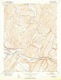
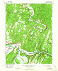 1950 Oldtown1965 Print · USGSThe Potomac River valley on the Maryland-West Virginia border comes alive in this mid-century survey of the historic Oldtown vicinity. Researchers can trace the path of the Chesapeake and Ohio Canal and locate rural landmarks like Mount Olive Church and Pumpkin Center.2 unique versions available
 - 1950 Map of Paw Paw, 1967 Print
 1950 Paw Paw1967 Print · USGSThe Potomac River oxbows at the West Virginia-Maryland border in the mid-century, where the rail-and-canal economy shaped the mountain landscape. Trace the historic route of the Baltimore and Ohio Railroad past Magnolia and find rural sites like Milo School and Sulphur Springs Ch.3 unique versions available
 - 1951 Map of Paw Paw
 1951 Paw Paw1951 Print · USGSThe Potomac River's serpentine bends at the West Virginia-Maryland border define this mid-century landscape of heavy rail and mountain ridges. Genealogists and industrial historians can trace the Chesapeake and Ohio Canal and family sites like Cherry Orchard Cem or the Milo School.
 - 1951 Map of Patterson Creek
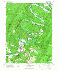
 1951 Patterson Creek1951 Print · USGSMaryland and West Virginia meet along the Potomac River in the early fifties, where heavy rail and abandoned canal works define the valley. Trace family history and industrial roots near Pattersons Creek, St Marys Cem, and the old Chesapeake and Ohio Canal.2 unique versions available
 - 1951 Map of Oldtown
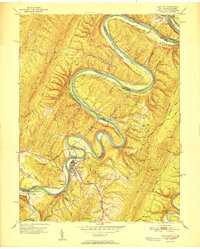
 1951 Oldtown1951 Print · USGSThe Potomac River borderlands in the early fifties reveal a complex network of mountain ridges and historic transportation corridors. Researchers can trace the path of the Chesapeake and Ohio Canal alongside the river and locate old communities like Oldtown, Okonoko, and Green Spring.2 unique versions available
 - 1952 Map of Cumberland
 1952 Cumberland1952 Print · USGSThe Potomac Highlands and the Shenandoah Valley are revealed in this early 1950s survey of the Appalachian interior. Researchers can trace the river-and-rail corridors connecting Cumberland, Winchester, and the recreational waters of Deep Creek Lake.
 - 1956 Map of Cumberland, 1966 Print
 1956 Cumberland1966 Print · USGSThe tri-state Highlands in the mid-1950s show a landscape shaped by coal, timber, and the massive presence of the Baltimore & Ohio RR. Researchers can trace the industrial corridor from Cumberland through the Allegheny Mountains to mountain retreats like Deep Creek Lake.6 unique versions available
 - 1957 Map of Cumberland
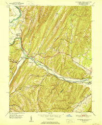
 1957 Cumberland1957 Print · USGSThe Potomac River valley and the ridges of the Allegheny Front define this mid-century landscape at the intersection of Maryland, West Virginia, and Pennsylvania. Trace the steam-era rail lines of the Baltimore and Ohio RR or locate rural landmarks like St Stephens Church and Stony River Dam.
End of results
Showing maps 1-8 of 8
Top cities of Hampshire County
Frequently asked questions
- What are the different types of historical maps available for Hampshire County?
- What is the oldest map of Hampshire County?
- Where can I purchase historical maps of Hampshire County for my home or office?
- Where can I download high-res historical maps of Hampshire County?
- Are there historical topographic maps available for Hampshire County?
- Is there historical aerial imagery available for Hampshire County?
- Where are historical maps of Hampshire County sourced from?