1960s Maps of Hampshire County, West Virginia
Explore 8 historic maps of Hampshire County from the 1960s. These maps offer a rare glimpse into what life looked like during the 1960s — showing old roads, neighborhoods, homes, and landmarks that have changed or disappeared over time.
Whether you're researching your family's past, planning a metal detecting trip, or studying how Hampshire County's landscape evolved across the 1960s, these high-resolution maps are a powerful tool for exploring the history of this region.
- Focus on a specific era: All maps on this page are from the 1960s, giving you a focused view of this time period.
- See what’s changed: Compare century-old streets, trails, and buildings to today's modern landscape using overlays and satellite layers.
- Research with precision: Use these maps for genealogy, historical research, land use analysis, or educational projects.
- View, download, or print: Maps are fully viewable online in high resolution, and can be downloaded or printed for your own records.
Start exploring Hampshire County's history through authentic maps from the 1960s. This is your window into the past.
Hampshire County, WV maps
(8)- 1961 Map of Cumberland
 1961 Cumberland1961 Print · USGSThe tri-state highlands of Maryland, West Virginia, and Pennsylvania are shown in the mid-twentieth century as a complex landscape of ridges and river valleys. Researchers can trace the winding Potomac River and find old rail-and-river towns like Cumberland, Keyser, and Morgantown.
 - 1962 Map of Cumberland
 1962 Cumberland1962 Print · USGSThe central Appalachians meet at the height of the mid-century industrial era, showing the rugged topography between Morgantown and Winchester. Genealogists can trace family lands near Fort Necessity or along the vital Baltimore & Ohio RR corridors.
 - 1965 Map of Wardensville, 1967 Print
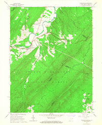 1965 Wardensville1967 Print · USGSWardensville and the surrounding mountain ridges come into focus in the mid-sixties, illustrating the deep ties between the valley floor and the high forest. Local historians can trace the sites of the Old Iron Furnace, the Clagett Cem, and Marvin Chapel.3 unique versions available
 - 1965 Map of Capon Bridge, 1967 Print
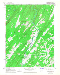 1965 Capon Bridge1967 Print · USGSIn the mid-1960s, the boundary between West Virginia and Virginia followed the high ridges of the Appalachians near Capon Bridge. Genealogists and hikers can trace old mountain paths like the Edwards Trail or locate rural landmarks such as Sandy Ridge Cem Ch and Cold Stream.3 unique versions available
 - 1965 Map of Ridge, 1967 Print
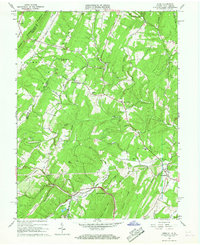
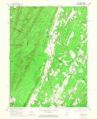 1965 Ridge1967 Print · USGSThe West Virginia and Virginia borderlands come to life in this mid-1960s survey of Morgan and Hampshire counties. Genealogists and historians can trace old homesteads and churches from Bloomery to Oakland, including Timber Ridge Ch and Reynolds Store.3 unique versions available
 - 1965 Map of Capon Springs, 1967 Print
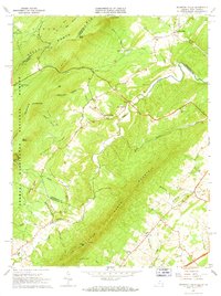
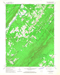 1965 Capon Springs1967 Print · USGSHampshire County and the Virginia borderlands are captured here in the mid-1960s as a hub for mountain resorts and timber-ridged valleys. Researchers can trace the resort grounds at Capon Springs, find ancestral sites like Racey Cem, or locate the old Capon Sch.2 unique versions available
 - 1965 Map of Gore, 1967 Print
 1965 Gore1967 Print · USGSIn the mid-1960s, the border between Virginia and West Virginia was defined by the rugged crossings of Timber Ridge and the Winchester and Western rail line. Genealogists can locate family landmarks like Ebenezer Church, the Gainesboro School, and the historic path of Braddock Road.4 unique versions available
 - 1965 Map of Mountain Falls, 1968 Print
 1965 Mountain Falls1968 Print · USGSThe Virginia and West Virginia borderlands in the mid-1960s reveal a landscape of mountain ridges and secluded valley settlements. Genealogists and historians can trace family locations through landmarks like Star Tannery, Gravel Springs Cem, and the Mineral Mine.3 unique versions available
End of results
Showing maps 1-8 of 8
Top cities of Hampshire County
Frequently asked questions
- What are the different types of historical maps available for Hampshire County?
- What is the oldest map of Hampshire County?
- Where can I purchase historical maps of Hampshire County for my home or office?
- Where can I download high-res historical maps of Hampshire County?
- Are there historical topographic maps available for Hampshire County?
- Is there historical aerial imagery available for Hampshire County?
- Where are historical maps of Hampshire County sourced from?