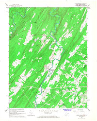
1965 Map of Capon Bridge
USGS Topo · Published 1967About this map
Capon Bridge sits at the heart of this mid-1960s survey, where the Cacapon River winds through the Appalachian ridges of Hampshire and Frederick Counties. The landscape is defined by long, parallel mountain ranges like Ice Mountain, Bear Garden Mountain, and Capon Mountain, which dictated the early path of historic routes such as the Edwards Trail and Schaffenaker Trail. The settlement patterns here remain deeply tied to the terrain, with small clusters of activity at Cold Stream and the village of Gore.
Find a feature on this map
40 named features on this map. Tap any name to fly to it.
Don’t see what you’re looking for? This feature index may not catch every label — zoom into the map to look around manually.
Map Details
Editions of this 1965 Capon Bridge Map
3 editions found
Other maps of this area

1891 · Romney
USGS Topo · 1:125,000

1894 · Winchester
USGS Topo · 1:125,000

1916 · Capon Bridge
USGS Topo · 1:62,500

1921 · Hanging Rock
USGS Topo · 1:48,000

1922 · Wardensville
USGS Topo · 1:62,500

1923 · Middletown
USGS Topo · 1:62,500

1923 · Capon Bridge
USGS Topo · 1:62,500

1923 · Hanging Rock
USGS Topo · 1:62,500

1924 · Wardensville
USGS Topo · 1:62,500

1937 · Capon Bridge
USGS Topo · 1:48,000