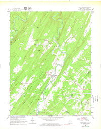
1965 Map of Capon Bridge
USGS Topo · Published 1979About this map
The Cacapon River winds through this West Virginia and Virginia border region, carving a deep valley between Bear Garden Mountain and the ridge of Schaffenaker Mountain. The settlement of Capon Bridge serves as a central hub where the waterway is flanked by rural infrastructure, including the nearby Capon Chapel and a Roadside Park. This 1965 survey reveals a landscape defined by isolated mountain gaps and small agricultural clearings, with the Hampshire and Frederick county line cutting across the eastern slopes. Local history is deeply etched into the terrain through numerous small country churches like Sandy Ridge Cem Ch and Mt Olive Ch. The northern reaches include the distinctive Ice Mountain and the small community of Gore, while the narrow drainage of Bloomery Run illustrates the tight topography that dictated early road and settlement patterns in the Potomac Highlands.
Find a feature on this map
43 named features on this map. Tap any name to fly to it.
Don’t see what you’re looking for? This feature index may not catch every label — zoom into the map to look around manually.
Map Details
Editions of this 1965 Capon Bridge Map
3 editions found
Other maps of this area

1891 · Romney
USGS Topo · 1:125,000

1894 · Winchester
USGS Topo · 1:125,000

1916 · Capon Bridge
USGS Topo · 1:62,500

1921 · Hanging Rock
USGS Topo · 1:48,000

1922 · Wardensville
USGS Topo · 1:62,500

1923 · Middletown
USGS Topo · 1:62,500

1923 · Capon Bridge
USGS Topo · 1:62,500

1923 · Hanging Rock
USGS Topo · 1:62,500

1924 · Wardensville
USGS Topo · 1:62,500

1937 · Capon Bridge
USGS Topo · 1:48,000