1970s Maps of Randolph County, West Virginia
Explore 17 historic maps of Randolph County from the 1970s. These maps offer a rare glimpse into what life looked like during the 1970s — showing old roads, neighborhoods, homes, and landmarks that have changed or disappeared over time.
Whether you're researching your family's past, planning a metal detecting trip, or studying how Randolph County's landscape evolved across the 1970s, these high-resolution maps are a powerful tool for exploring the history of this region.
- Focus on a specific era: All maps on this page are from the 1970s, giving you a focused view of this time period.
- See what’s changed: Compare century-old streets, trails, and buildings to today's modern landscape using overlays and satellite layers.
- Research with precision: Use these maps for genealogy, historical research, land use analysis, or educational projects.
- View, download, or print: Maps are fully viewable online in high resolution, and can be downloaded or printed for your own records.
Start exploring Randolph County's history through authentic maps from the 1970s. This is your window into the past.
Randolph County, WV maps
(17)- 1970 Map of Sinks of Gandy, 1973 Print
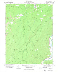
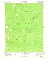
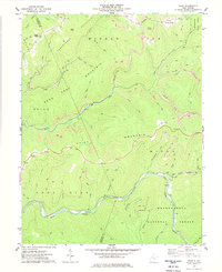
 1970 Sinks of Gandy1973 Print · USGSThe Allegheny Mountains around Osceola and the Sinks of Gandy appear here in the early seventies, spanning three West Virginia counties. Researchers can trace remote mountain geography including the Blister Swamp, The Pigs Ear, and several family-named landmarks like Yokum Knob.2 unique versions available
 - 1970 Map of Spruce Knob, 1973 Print
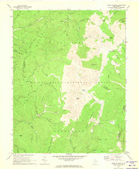
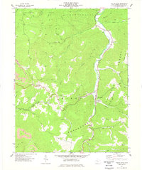
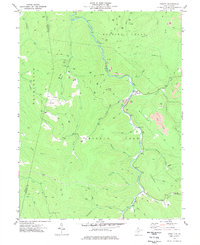
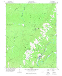
 1970 Spruce Knob1973 Print · USGSThe West Virginia highlands around Cherry Grove are documented here in the early 1970s, showcasing the state's highest peak. Researchers can trace family landmarks and rural life through Big Run Chapel, Spruce Knob Lookout Tower, and Spruce Knob Lake.
 - 1974 Map of Snyder Knob, 1989 Print
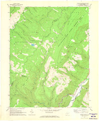
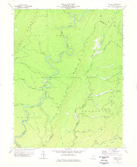
 1974 Snyder Knob1989 Print · USGSHigh in the West Virginia mountains during the mid-seventies, this survey shows a landscape of timber and mining. Genealogists and historians can locate the Fort Milroy Cem and trace the drainage of the Shavers Fork near Cheat Bridge.
 - 1977 Map of Pickens
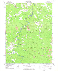
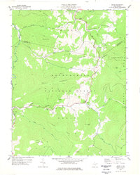
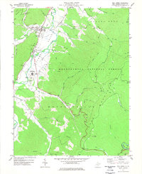
 1977 Pickens1977 Print · USGSRandolph and Upshur counties are shown during the late 1970s, highlighting the historic Swiss enclave of Helvetia and the mountain village of Pickens. Genealogists and historians can trace the Baltimore and Ohio rail lines, old logging grades, and local burial sites like Pine Grove Cemetery.
 - 1977 Map of Adolph
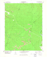
 1977 Adolph1977 Print · USGSRandolph County's high ridges and river valleys are captured here during the late seventies, showing the deep woods of the Kumbrabow State Forest. Genealogists and historians can locate old landmarks like Old Fort, Pleasant Chapel, and the settlement of Adolph.
 - 1977 Map of Valley Head
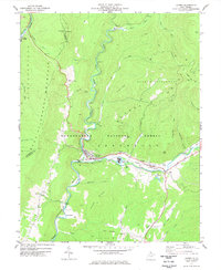
 1977 Valley Head1977 Print · USGSRandolph County in the 1970s shows a landscape of steep timberlands and river-bottom settlements along the Tygart Valley River. Researchers can locate family landmarks like the Stalnaker Cem, Oakgrove Ch, and the high pass at Brady Gate.2 unique versions available
 - 1977 Map of Wildell
 1977 Wildell1977 Print · USGSHigh in the Allegheny Mountains during the 1970s, this area shows a landscape defined by industrial rail and wilderness conservation. You can trace the Western Maryland Railway through the peaks, finding remote spots like Wildell and the Clubhouse.
 - 1977 Map of Ellamore
 1977 Ellamore1977 Print · USGSThe Middle Fork River valley comes into focus during the late seventies, showing a landscape defined by coal, gas, and timber. Researchers can trace family roots at Mt Zion Cem, locate the old Tall Oaks Roadside Park, or explore the rail-dependent hamlets of Ellamore and Midvale.2 unique versions available
 - 1977 Map of Snyder Knob
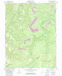
 1977 Snyder Knob1977 Print · USGSRandolph and Pocahontas counties appear here in the 1970s, dominated by the high ridgelines of the Monongahela National Forest. Local historians can locate the historic Fort Milroy Cem and trace the winding waters of Shavers Fork past Cheat Bridge.
 - 1977 Map of Cassity
 1977 Cassity1977 Print · USGSRandolph County's coal and gas country is captured here in the late seventies, centered on the Middle Fork River valley. Genealogists and researchers can locate old communities like Cassity and Cubana, or trace the Simmons Cem and the former location of Long Run (Site).
 - 1977 Map of Mingo
 1977 Mingo1977 Print · USGSHigh in the Alleghenies during the late seventies, this survey shows the transition from traditional mountain settlements to modern recreation. Researchers can trace the Western Maryland rail line and locate family sites like Varner Cem near the Snowshoe Ski Area.
 - 1977 Map of Durbin
 1977 Durbin1977 Print · USGSPocahontas County was a vital rail and river crossroads in the late seventies, where the timber and coal industries met the mountain forest. Genealogists and historians can trace family locations at Burner Settlement, Bethel Ch, and the Yeager Cem.2 unique versions available
 - 1977 Map of Samp
 1977 Samp1977 Print · USGSIn the late seventies, the rugged border of Webster and Randolph Counties remained a land of high ridges and deep river forks. Genealogists and historians can locate quiet burial grounds like Samp Cem and Cowger Cem or trace industrial activity at various mountain-top Strip Mines.2 unique versions available
 - 1977 Map of Mill Creek
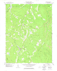
 1977 Mill Creek1977 Print · USGSThe Tygart Valley River corridor comes alive in the late 1970s, showing the riverside growth of Huttonsville and Mill Creek. Local historians can trace the foundations of the Tygart Valley High Sch and find remote ridge markers like Hutton Knob and Cromer Top.2 unique versions available
 - 1977 Map of Cass, 1978 Print
 1977 Cass1978 Print · USGSPocahontas County in the late seventies is defined by its deep river valleys and high mountain logging history. Genealogists and historians can trace the timber and rail economy through Cass Scenic Railroad, Whitaker Station, and the remote settlement at Spruce.
 - 1977 Map of Sharp Knob, 1978 Print
 1977 Sharp Knob1978 Print · USGSThe high ridges of the Monongahela National Forest are captured in the late seventies as industrial activity shaped the mountains. Researchers can trace the Western Maryland Railroad Grade and locate numerous Strip Mines near Sharp Knob Lookout Tower.
 - 1979 Map of Marlinton, 1982 Print
 1979 Marlinton1982 Print · USGSThe West Virginia highlands are shown in detail during the late seventies, featuring the dense rail networks and mountain towns of the Allegheny range. Researchers can trace family roots through sites like Buckeye Cem, Mount Nebo Ch, and the lumber and coal hubs of Richwood and Rainelle.
End of results
Showing maps 1-17 of 17
Top cities of Randolph County
- Elkins historical maps
- Beverly historical maps
- Mill Creek historical maps
- Valley Bend historical maps
- East Dailey historical maps
- Norton historical maps
See more
Frequently asked questions
- What are the different types of historical maps available for Randolph County?
- What is the oldest map of Randolph County?
- Where can I purchase historical maps of Randolph County for my home or office?
- Where can I download high-res historical maps of Randolph County?
- Are there historical topographic maps available for Randolph County?
- Is there historical aerial imagery available for Randolph County?
- Where are historical maps of Randolph County sourced from?