1990s Maps of Randolph County, West Virginia
Explore 24 historic maps of Randolph County from the 1990s. These maps offer a rare glimpse into what life looked like during the 1990s — showing old roads, neighborhoods, homes, and landmarks that have changed or disappeared over time.
Whether you're researching your family's past, planning a metal detecting trip, or studying how Randolph County's landscape evolved across the 1990s, these high-resolution maps are a powerful tool for exploring the history of this region.
- Focus on a specific era: All maps on this page are from the 1990s, giving you a focused view of this time period.
- See what’s changed: Compare century-old streets, trails, and buildings to today's modern landscape using overlays and satellite layers.
- Research with precision: Use these maps for genealogy, historical research, land use analysis, or educational projects.
- View, download, or print: Maps are fully viewable online in high resolution, and can be downloaded or printed for your own records.
Start exploring Randolph County's history through authentic maps from the 1990s. This is your window into the past.
Randolph County, WV maps
(24)- 1995 Map of Beverly East, 1998 Print
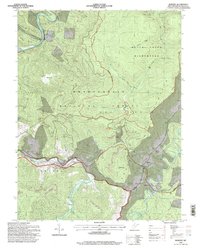
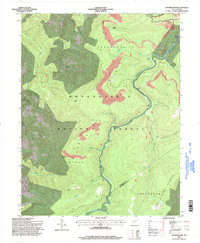
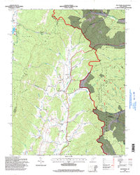
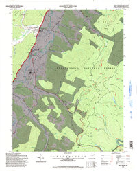
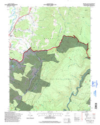 1995 Beverly East1998 Print · USGSThe Randolph County highlands are captured here in the mid-1990s as the river-and-rail landscape of the Alleghenies continues to evolve. Genealogists and hikers can trace the Allegheny Trail through the Monongahela National Forest and locate points like Elk River Junction or Hazelwood.
 - 1995 Map of Mingo, 1998 Print
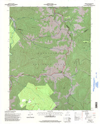 1995 Mingo1998 Print · USGSThe high ridges of Pocahontas County come into focus in the mid-1990s as the Tygart Valley and Elk Rivers begin their descent from the forest. Genealogists and local historians can trace the mountain communities of Mingo, Mace, and Linwood, and locate landmarks like the Varner Cemetery and Big Spring Church.
 - 1995 Map of Durbin, 1998 Print
 1995 Durbin1998 Print · USGSThe West Virginia highlands in the 1990s show a mix of timber industry, coal processing, and small-town life. Genealogists and historians can trace family locations through Bethel Ch, Yeager Cem, and the old Burner Settlement.
 - 1995 Map of Samp, 1998 Print
 1995 Samp1998 Print · USGSThe West Virginia highlands in the 1990s show a landscape where conservation and industry meet among the high ridges. Researchers can trace the river-centered settlements of Waneta and Samp or locate industrial sites like the Mill and several Strip Mines near Whitaker Falls.
 - 1995 Map of Elkins, 1998 Print
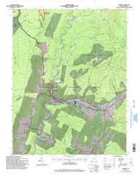
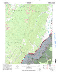
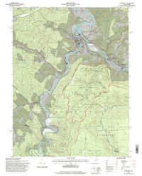
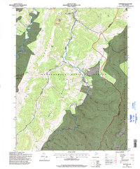
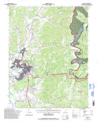 1995 Elkins1998 Print · USGSThe Tygart Valley and the ridges of the Monongahela National Forest meet at Elkins in the 1990s. Trace local history at Davis and Elkins College, the Elkins-Randolph County Airport, and the IOOF Cem.
 - 1995 Map of Harman, 1998 Print
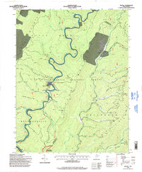
 1995 Harman1998 Print · USGSRandolph and Tucker counties in the mid-1990s show a region of high mountain ridges and river-bottom settlements. Genealogists and hikers can trace the winding Dry Fork, locate the Riverside Ch, and explore trails through the Otter Creek Wilderness.2 unique versions available
 - 1995 Map of Sharp Knob, 1998 Print
 1995 Sharp Knob1998 Print · USGSThe West Virginia highlands in the mid-1990s show a landscape of resource extraction and mountain wilderness where three counties meet. Researchers can trace historic mining operations near Bergoo Creek or follow the Gauley Mountain Trail across Sharp Knob.
 - 1995 Map of Spruce Knob, 1998 Print
 1995 Spruce Knob1998 Print · USGSThe West Virginia highlands appear in the mid-nineties as a recreation hub centered around the state's highest peak. Genealogists and hikers can trace the paths near Cherry Grove and find landmarks like Big Run Chapel or the Spruce Knob lookout.
 - 1995 Map of Bowden, 1998 Print
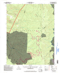
 1995 Bowden1998 Print · USGSRandolph County highlands come into focus in the mid-1990s as the river-driven industry of the Shaver Fork valley meets wilderness preservation. Researchers can trace rural life and industry through the Fish Hatchery at Bowden, the Tipple near Evenwood, and high points like Bickle Knob.2 unique versions available
 - 1995 Map of Adolph, 1998 Print
 1995 Adolph1998 Print · USGSRandolph County's mountain wilderness is captured here in the mid-1990s, revealing a landscape of dense state and national forests. Genealogists and local historians can trace rural settlements along the river valleys like Adolph and Elkwater, or locate landmarks such as Old Fort and Pleasant Chapel.
 - 1995 Map of Valley Head, 1998 Print
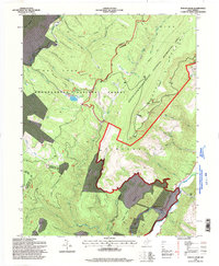
 1995 Valley Head1998 Print · USGSThe Tygart Valley River headwaters near Valley Head were documented in the mid-1990s as the high-elevation forest lands transitioned. Genealogists can locate family landmarks like Stalnaker Cem and Ware Cem alongside small communities like Monterville and Blue Spring.
 - 1995 Map of Sinks of Gandy, 1998 Print
 1995 Sinks of Gandy1998 Print · USGSThe high Allegheny backcountry of Randolph and Pocahontas counties is captured here in the mid-nineties, before modern development reached these remote ridges. Researchers can locate the famous Sinks of Gandy cavern entrance, the settlement of Osceola, and high-altitude landmarks like Blister Swamp.
 - 1995 Map of Snyder Knob, 1998 Print
 1995 Snyder Knob1998 Print · USGSHigh in the mountains of West Virginia during the mid-nineties, this survey captures the intersection of industrial extraction and national forest lands. Researchers can locate the Fort Milroy Cem and trace the winding course of the Shavers Fork past landmark peaks like Barton Knob.
 - 1995 Map of Beverly West, 1998 Print
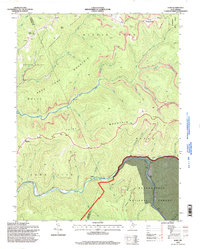
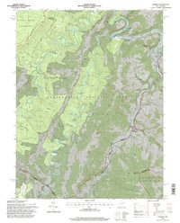
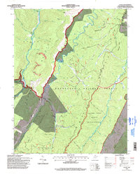
 1995 Beverly West1998 Print · USGSThe Tygart Valley during the mid-1990s reveals a landscape shaped by coal mining and established river settlements. Local historians can trace family locations near the Homestead Sch, the Valley Bend Ch, and the high ridges of Rich Mountain.
 - 1995 Map of Glady, 1998 Print
 1995 Glady1998 Print · USGSThe river valleys and ridges of Randolph County come alive in the mid-nineties, showing the remote settlements of Bemis and Glady. Local researchers can trace family landmarks and industry through the Cem near the river or the legacy of a Strip Mine on the mountain.
 - 1995 Map of Hopeville, 1998 Print
 1995 Hopeville1998 Print · USGSThe West Virginia highlands in the mid-1990s reveal a landscape of deep river valleys and high wilderness plateaus. Researchers can trace remote mountain communities like Hopeville and Ketterman, as well as landmarks like Smoke Hole Caverns and Pleasant Valley Ch.
 - 1995 Map of Montrose, 1998 Print
 1995 Montrose1998 Print · USGSThe West Virginia highlands near Montrose are captured here in the mid-1990s as the Monongahela National Forest meets valley settlements. Genealogists and local historians can trace rural landmarks from Union Chapel to the community of Smith Crossing and the Elkins Speedway.
 - 1995 Map of Parsons, 1998 Print
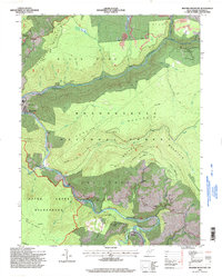
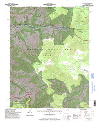
 1995 Parsons1998 Print · USGSTucker County mountain life is centered on the forks of the Cheat River in the mid-nineties. Genealogists and historians can locate family-named sites like Irons Chapel, Hamrick Sch, and Collett Cem among the reaches of the Otter Creek Wilderness.2 unique versions available
 - 1995 Map of Wildell, 1998 Print
 1995 Wildell1998 Print · USGSThe high ridges of West Virginia come into focus during the late twentieth century as coal extraction and conservation overlap. Researchers can find deep-woods landmarks like Enviro Energy Mine No 2, the settlement of Wildell, and the Johns Camp Run Shelter.
 - 1995 Map of Mozark Mountain, 1998 Print
 1995 Mozark Mountain1998 Print · USGSTucker County during the mid-1990s reveals a landscape defined by the convergence of mountain forks and deep wilderness protection. Genealogists and hikers can trace the connections between the riverside settlement of Hendricks, the remote community of Gladwin, and landmarks like Brights Chapel.2 unique versions available
 - 1995 Map of Mill Creek, 1998 Print
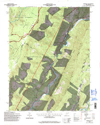
 1995 Mill Creek1998 Print · USGSRandolph County's Tygart Valley appears in the mid-nineties as a mix of river-bottom agriculture and mountain forest. Trace the layout of Huttonsville and Mill Creek, or locate local landmarks like the Old Brick Ch Cemetery and Edwards Chapel.
 - 1995 Map of Laneville, 1998 Print
 1995 Laneville1998 Print · USGSHigh Allegheny plateaus and the headwaters of Red Creek define this West Virginia mountain landscape during the mid-1990s. Researchers can locate remote sites like Flanagan Memorial Cem, the Bethel Ch, and landmarks like Thunderstruck Rock.
 - 1995 Map of Cass, 1998 Print
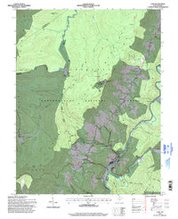 1995 Cass1998 Print · USGSPocahontas County at the close of the century shows a landscape defined by the Cass Scenic Railroad and the rise of winter sports. Trace the old timber grades near Spruce and heritage sites like Whittaker Station and Hilltop Cem.
 - 1995 Map of Whitmer, 1998 Print
 1995 Whitmer1998 Print · USGSThe Dry Fork valley in the mid-nineties shows the isolated settlements and mountain ridges of the West Virginia high country. Genealogists and hikers can trace family-named creeks and remote outposts like Whitmer, Little Italy, and the high-elevation Judy Springs.
End of results
Showing maps 1-24 of 24
Top cities of Randolph County
- Elkins historical maps
- Beverly historical maps
- Mill Creek historical maps
- Valley Bend historical maps
- East Dailey historical maps
- Norton historical maps
See more
Frequently asked questions
- What are the different types of historical maps available for Randolph County?
- What is the oldest map of Randolph County?
- Where can I purchase historical maps of Randolph County for my home or office?
- Where can I download high-res historical maps of Randolph County?
- Are there historical topographic maps available for Randolph County?
- Is there historical aerial imagery available for Randolph County?
- Where are historical maps of Randolph County sourced from?