1980s Maps of Milwaukee, Wisconsin
Explore 4 historic maps of Milwaukee from the 1980s. These maps offer a rare glimpse into what life looked like during the 1980s — showing old roads, neighborhoods, homes, and landmarks that have changed or disappeared over time.
Whether you're researching your family's past, planning a metal detecting trip, or studying how Milwaukee's landscape evolved across the 1980s, these high-resolution maps are a powerful tool for exploring the history of this region.
- Focus on a specific era: All maps on this page are from the 1980s, giving you a focused view of this time period.
- See what’s changed: Compare century-old streets, trails, and buildings to today's modern landscape using overlays and satellite layers.
- Research with precision: Use these maps for genealogy, historical research, land use analysis, or educational projects.
- View, download, or print: Maps are fully viewable online in high resolution, and can be downloaded or printed for your own records.
Start exploring Milwaukee's history through authentic maps from the 1980s. This is your window into the past.
Milwaukee, WI maps
(4)- 1980 Map of Milwaukee, 1981 Print
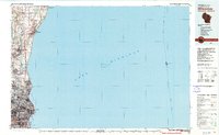 1980 Milwaukee1981 Print · USGSThe Lake Michigan shoreline and Milwaukee's urban sprawl are captured here at the start of the 1980s. Local researchers can trace family landmarks like Graceland Cemetery, educational sites like Milwaukee-Downer College, and the northern rail lines of the Chicago and North Western.
 - 1980 Map of Lake Geneva, 1981 Print
 1980 Lake Geneva1981 Print · USGSSoutheastern Wisconsin at the start of the eighties reveals a landscape of glacial moraines and established lakefront resorts. Researchers can trace historic rail lines like the Chicago and North Western RR or locate landmarks such as Yerkes Observatory and East Lawn Cem.
 - 1980 Map of Racine, 1981 Print
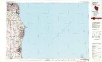 1980 Racine1981 Print · USGSThe Lake Michigan shoreline at the start of the 1980s reveals a bustling industrial corridor from Milwaukee to Kenosha. Genealogists and local historians can trace family roots through numerous sites like Forest Home Cem or locate former rail stops along the C & N W and C M St P & P lines.
 - 1984 Map of Oconomowoc, 1985 Print
 1984 Oconomowoc1985 Print · USGSSoutheast Wisconsin in the mid-eighties shows a landscape defined by its glacial heritage and expanding metropolitan corridors. Genealogists and historians can trace the development of lakeside communities like Oconomowoc and Pewaukee, or find established settlements such as Watertown and Beaver Dam.
End of results
Showing maps 1-4 of 4
Top cities near Milwaukee
- Waukesha historical maps
- West Allis historical maps
- Wauwatosa historical maps
- Brookfield historical maps
- New Berlin historical maps
- Franklin historical maps
See more
Top neighborhoods of Milwaukee
- West Granville historical maps
- Granville historical maps
- Bay View historical maps
- Lindsay Heights historical maps
- Riverwest historical maps
- Menomonee River Valley historical maps
See more
Frequently asked questions
- What are the different types of historical maps available for Milwaukee?
- What is the oldest map of Milwaukee?
- Where can I purchase historical maps of Milwaukee for my home or office?
- Where can I download high-res historical maps of Milwaukee?
- Are there historical topographic maps available for Milwaukee?
- Is there historical aerial imagery available for Milwaukee?
- Where are historical maps of Milwaukee sourced from?