1990s Maps of Outagamie County, Wisconsin
Explore 17 historic maps of Outagamie County from the 1990s. These maps offer a rare glimpse into what life looked like during the 1990s — showing old roads, neighborhoods, homes, and landmarks that have changed or disappeared over time.
Whether you're researching your family's past, planning a metal detecting trip, or studying how Outagamie County's landscape evolved across the 1990s, these high-resolution maps are a powerful tool for exploring the history of this region.
- Focus on a specific era: All maps on this page are from the 1990s, giving you a focused view of this time period.
- See what’s changed: Compare century-old streets, trails, and buildings to today's modern landscape using overlays and satellite layers.
- Research with precision: Use these maps for genealogy, historical research, land use analysis, or educational projects.
- View, download, or print: Maps are fully viewable online in high resolution, and can be downloaded or printed for your own records.
Start exploring Outagamie County's history through authentic maps from the 1990s. This is your window into the past.
Outagamie County, WI maps
(17)- 1992 Map of New London, 1995 Print
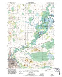 1992 New London1995 Print · USGSThe riverfront city of New London and the nearby settlement of Sugar Bush are captured here as they appeared in the early nineties. Genealogists and local historians can trace family-named sites like Ruckdashel Cem and landmarks such as Mosquito Hill.
 - 1992 Map of Freedom, 1996 Print
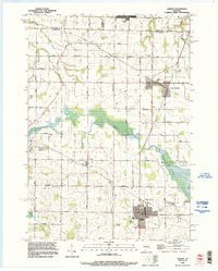
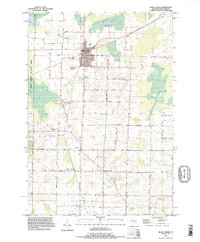
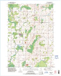
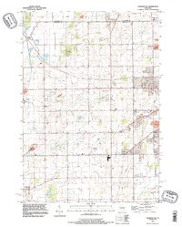
 1992 Freedom1996 Print · USGSOutagamie County in the early nineties is a patchwork of historic farmsteads and reservation lands. Genealogists and local historians can trace burial sites like St John the Baptist Cemetery and old crossroads like Chicago Corners or Murphy Corner.
 - 1992 Map of Hilbert, 1996 Print
 1992 Hilbert1996 Print · USGSCalumet and Brown counties are mapped here in the early 1990s, capturing a landscape of dairy-country road grids and quiet village life. Genealogists can trace family landmarks like Saint Peters Cemetery, the Forest Assembly Ground, and the small settlement of St John.
 - 1992 Map of Oneida South, 1996 Print
 1992 Oneida South1996 Print · USGSThe Oneida Reservation and Brown County borderland are captured here in the early nineties as modern development met historic settlements. Genealogists and local historians can trace family-named routes like Van Boxtel Road or locate Saint Joseph Cemetery and the grounds of Lost Dauphin State Park.
 - 1992 Map of Black Creek, 1996 Print
 1992 Black Creek1996 Print · USGSNorthern Outagamie County is documented here in the early nineties, centered on the village of Black Creek. Genealogists can locate family burial sites at Sassman Cem or Saint Petri Cem and trace rural settlements like Binghamton and Twelve Corners.
 - 1992 Map of Leeman, 1996 Print
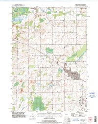
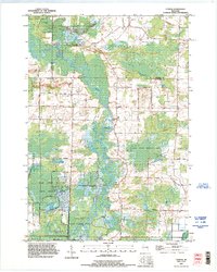 1992 Leeman1996 Print · USGSIn the 1990s, the Wolf River basin in Outagamie County remained a vast wetland corridor preserved through state wildlife areas. Researchers can trace rural lineages at St Lawrence Cem and Oak Hill Cem or locate the riverside hamlet of Leeman.
 - 1992 Map of Neenah, 1996 Print
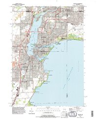 1992 Neenah1996 Print · USGSThe Fox River Valley saw significant development in the early nineties, centered on the growing industrial and residential districts of Neenah and Menasha. Genealogists and local historians can trace family locations through numerous sites like St Patricks Cem, Stroebe Island, and the rail corridors of the Soo Line.
 - 1992 Map of Oneida North, 1996 Print
 1992 Oneida North1996 Print · USGSThe rural stretches and growing outskirts northwest of Green Bay are captured here in the early nineties as suburban expansion met long-standing farming communities. Researchers can trace local heritage through the Owego Cemetery, the institutional State Reformatory Farm, and the early footprints of Anston and Oneida.
 - 1992 Map of Nichols, 1996 Print
 1992 Nichols1996 Print · USGSThe rural landscapes of Shawano and Outagamie counties are captured here in the early nineties, showcasing the agricultural roots of Nichols and Briarton. Local researchers can trace family landmarks like Emmanuel Cem and several small extractive sites including a Quarry and Gravel Pit.
 - 1992 Map of Greenville, 1996 Print
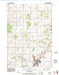
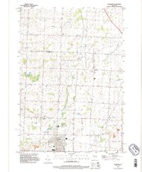
 1992 Greenville1996 Print · USGSThe Outagamie County countryside near Greenville is shown here in the 1990s as suburban expansion begins to meet established dairy and river lands. Researchers can locate family plots at Wanderers Rest Cemetery and trace the early footprint of the Outagamie County Airport.
 - 1992 Map of Shiocton, 1996 Print
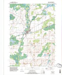 1992 Shiocton1996 Print · USGSShiocton sits at a prominent bend in the Wolf River during the late twentieth century, surrounded by extensive wildlife areas and winding waterways. Genealogists and researchers can locate family-named landmarks like Rexford Cem, Bovina Gem, and Pluger Road.
 - 1992 Map of Kaukauna, 1996 Print
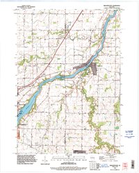
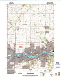 1992 Kaukauna1996 Print · USGSThe Fox River industrial corridor is shown in high detail during the early nineties as urban centers like Kaukauna and Little Chute expanded. Genealogists can locate several local burial grounds such as St John Cem and Holy Name Cemetery alongside parks like Thousand Island State Conservancy Park.
 - 1992 Map of Sherwood, 1996 Print
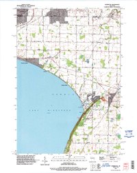 1992 Sherwood1996 Print · USGSLake Winnebago and its prominent eastern bluffs are the centerpiece of this Calumet County survey from the early nineties. Researchers can locate genealogical landmarks like High Cliff Cemetery or trace the industrial history of the Limekiln Ruins and local Quarry operations.
 - 1992 Map of Seymour, 1996 Print
 1992 Seymour1996 Print · USGSThe agricultural lands north of Seymour are captured in the 1990s, where the rural crossroads of Isaar and Rose Lawn anchor the landscape. Genealogists can locate family sites at Elm Lawn Cem and Owego Cem while tracing the Oneida reservation boundary.
 - 1992 Map of Appleton, 1996 Print
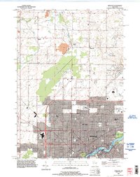 1992 Appleton1996 Print · USGSThe Fox River valley saw significant suburban and commercial expansion in the 1990s as the urban core pushed north. Genealogists and researchers can trace local landmarks like Lawrence College, Riverside Cem, and the rural crossroads of Mackville.
 - 1992 Map of Oshkosh NE, 1996 Print
 1992 Oshkosh NE1996 Print · USGSWinnebago County in the early nineties shows a landscape of rail-connected hamlets and growing aviation hubs northwest of Lake Winnebago. Researchers can trace the Soo Line through Medina Junction and find local landmarks like Larsen and Allenville.
 - 1992 Map of Wrightstown, 1996 Print
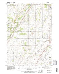
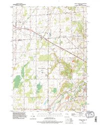
 1992 Wrightstown1996 Print · USGSThe Fox River valley in the early nineties shows a balance of industrial power and rural community life. Genealogists can locate several historic burial grounds including St Paul Cemetery and St Johns Cemetery, or trace the path of Plum Creek through Holland.
End of results
Showing maps 1-17 of 17
Top cities of Outagamie County
- Appleton historical maps
- Grand Chute historical maps
- Kaukauna historical maps
- Little Chute historical maps
- Greenville historical maps
- Kimberly historical maps
See more
Frequently asked questions
- What are the different types of historical maps available for Outagamie County?
- What is the oldest map of Outagamie County?
- Where can I purchase historical maps of Outagamie County for my home or office?
- Where can I download high-res historical maps of Outagamie County?
- Are there historical topographic maps available for Outagamie County?
- Is there historical aerial imagery available for Outagamie County?
- Where are historical maps of Outagamie County sourced from?