1950s Maps of Outagamie County, Wisconsin
Explore 11 historic maps of Outagamie County from the 1950s. These maps offer a rare glimpse into what life looked like during the 1950s — showing old roads, neighborhoods, homes, and landmarks that have changed or disappeared over time.
Whether you're researching your family's past, planning a metal detecting trip, or studying how Outagamie County's landscape evolved across the 1950s, these high-resolution maps are a powerful tool for exploring the history of this region.
- Focus on a specific era: All maps on this page are from the 1950s, giving you a focused view of this time period.
- See what’s changed: Compare century-old streets, trails, and buildings to today's modern landscape using overlays and satellite layers.
- Research with precision: Use these maps for genealogy, historical research, land use analysis, or educational projects.
- View, download, or print: Maps are fully viewable online in high resolution, and can be downloaded or printed for your own records.
Start exploring Outagamie County's history through authentic maps from the 1950s. This is your window into the past.
Outagamie County, WI maps
(11)- 1954 Map of De Pere, 1956 Print
 1954 De Pere1956 Print · USGSThe Fox River valley in the mid-1950s was a hub of industrial navigation and growing aviation between De Pere and Green Bay. Genealogists can trace family names through dozens of rural sites like St Patrick Cem, Gopher Hill, and the Michaelson Sch (Abandoned).2 unique versions available
 - 1954 Map of Chilton, 1956 Print
 1954 Chilton1956 Print · USGSMid-century Calumet County is captured here during a period of transition for its rural school districts and thriving rail corridors. Genealogists can locate family landmarks such as St Lukes Church, Brillion Cem, and several schoolhouses like the Howe Sch.3 unique versions available
 - 1954 Map of Green Bay, 1980 Print
 1954 Green Bay1980 Print · USGSGreen Bay and Brown County are shown during a period of steady mid-century growth and agricultural prominence. Researchers can trace family roots through numerous country schools like White Pine Sch and established cemeteries such as Chase Cem and Peace Cem.
 - 1955 Map of Neenah, 1957 Print
 1955 Neenah1957 Print · USGSMid-century Wisconsin comes to life along the Fox River and Lake Winnebago as industrial towns like Neenah and Menasha expand. Genealogists and historians can trace old property lines near St Marys Cem or locate defunct landmarks like the Drive-in Theater and Clay Sch.3 unique versions available
 - 1955 Map of Embarrass, 1957 Print
 1955 Embarrass1957 Print · USGSIn the mid-1950s, this pocket of Wisconsin was a landscape of dairy townships and evolving rural education. Genealogists can trace family roots through numerous sites like St John Ch, the Danish Cem, and many schoolhouses marked abandoned including Riverbank Sch.2 unique versions available
 - 1955 Map of Appleton, 1957 Print
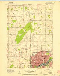 1955 Appleton1957 Print · USGSMid-century Appleton thrives as a river-based industrial and academic center during the mid-1950s. Genealogists and historians can trace the footprint of Lawrence College, numerous parochial schools like St Teresa Sch, and outlying hamlets such as Mackville.3 unique versions available
 - 1955 Map of Appleton, 1957 Print
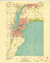
 1955 Appleton1957 Print · USGSOutagamie County's river-driven industrial valley and sprawling northern farmsteads are captured here in the mid-1950s. Genealogists and historians can trace the foundations of Appleton and Kaukauna or locate rural landmarks like Mackville Station and the Herman Sch (Abandoned).2 unique versions available
 - 1955 Map of Neenah, 1957 Print
 1955 Neenah1957 Print · USGSMid-century Neenah and Menasha show a bustling river-and-rail corridor at the mouth of Lake Winnebago. Genealogists and historians can trace neighborhood growth near Doty Island, locate family sites at Oak Hill Cem, or find recreation spots like Waverly Beach.3 unique versions available
 - 1955 Map of Seymour, 1957 Print
 1955 Seymour1957 Print · USGSWisconsin's dairy heartland comes alive in this mid-century survey of the borderlands between Shawano and Outagamie counties. Genealogists can trace family roots through numerous rural schools and churches, from St Johns Ch to the Elm Grove Cem near Laney.3 unique versions available
 - 1955 Map of Green Bay, 1968 Print
 1955 Green Bay1968 Print · USGSCentral and Eastern Wisconsin are captured here in the mid-fifties, showing the industrial growth of the Fox Valley and Wisconsin River corridors. Genealogists and historians can trace rail lines like the Green Bay and Western through settlements like Weyauwega, Clintonville, and Pulaski.2 unique versions available
 - 1956 Map of New London, 1958 Print
 1956 New London1958 Print · USGSWisconsin's Fox Valley region in the mid-fifties shows a landscape of river-town commerce and deep rural roots. Genealogists can trace family sites at Wanderers Rest Cem or locate the many country schools like Golden Hill Sch and Hickory Grove Sch.
End of results
Showing maps 1-11 of 11
Top cities of Outagamie County
- Appleton historical maps
- Grand Chute historical maps
- Kaukauna historical maps
- Little Chute historical maps
- Greenville historical maps
- Kimberly historical maps
See more
Frequently asked questions
- What are the different types of historical maps available for Outagamie County?
- What is the oldest map of Outagamie County?
- Where can I purchase historical maps of Outagamie County for my home or office?
- Where can I download high-res historical maps of Outagamie County?
- Are there historical topographic maps available for Outagamie County?
- Is there historical aerial imagery available for Outagamie County?
- Where are historical maps of Outagamie County sourced from?