1970s Maps of Crook County, Wyoming
Explore 14 historic maps of Crook County from the 1970s. These maps offer a rare glimpse into what life looked like during the 1970s — showing old roads, neighborhoods, homes, and landmarks that have changed or disappeared over time.
Whether you're researching your family's past, planning a metal detecting trip, or studying how Crook County's landscape evolved across the 1970s, these high-resolution maps are a powerful tool for exploring the history of this region.
- Focus on a specific era: All maps on this page are from the 1970s, giving you a focused view of this time period.
- See what’s changed: Compare century-old streets, trails, and buildings to today's modern landscape using overlays and satellite layers.
- Research with precision: Use these maps for genealogy, historical research, land use analysis, or educational projects.
- View, download, or print: Maps are fully viewable online in high resolution, and can be downloaded or printed for your own records.
Start exploring Crook County's history through authentic maps from the 1970s. This is your window into the past.
Crook County, WY maps
(14)- 1970 Map of Belle Creek South, 1973 Print
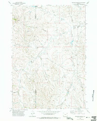
 1970 Belle Creek South1973 Print · USGSThe Montana-Wyoming borderlands at the start of the 1970s reveal a landscape in transition from ranching to energy. Researchers can locate the Walloth Sch, the Belle Creek Oil Field, and the Ridge Cem among the high plains.
 - 1970 Map of Stack Rocks, 1973 Print
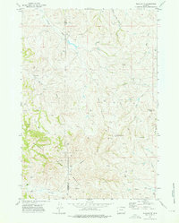
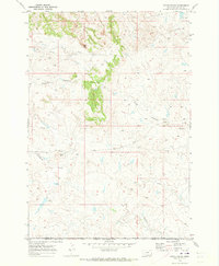 1970 Stack Rocks1973 Print · USGSThe Montana-Wyoming borderlands at the start of the 1970s show a remote landscape of high plains and geological landmarks. Genealogists and historians can trace the paths of Thompson Creek and locate notable features like Stack Rocks and the Rock Wall.
 - 1971 Map of Rozet SE, 1974 Print
 1971 Rozet SE1974 Print · USGSCrook and Campbell Counties reveal a landscape of energy and transport during the early 1970s. Genealogists and historians can trace the paths of Miller Road, locate the Pleasant Valley Cemetery, and map the extent of the Kummerfeld Oil Field.2 unique versions available
 - 1971 Map of Rozet NE, 1974 Print
 1971 Rozet NE1974 Print · USGSThe high plains of Crook County are shown during a peak era of energy extraction in the early seventies. Genealogists and industrial historians can trace the network of the Rozet Oil Field and the complex drainages of North Miller Creek and Little Pine Ridge.
 - 1971 Map of Whitetail Creek NE, 1975 Print
 1971 Whitetail Creek NE1975 Print · USGSNortheastern Wyoming in the early seventies shows a landscape heavily shaped by energy production at the tri-county junction. Researchers can trace the footprints of the Duvall Ranch Oil Field, a remote Landing Strip, and the winding Belle Fourche River.
 - 1972 Map of Bonnie Reservoir, 1975 Print
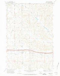
 1972 Bonnie Reservoir1975 Print · USGSThe high plains of the Campbell and Crook county line appear here in the early seventies as a landscape of remote ranching and emerging energy infrastructure. Researchers can trace local landmarks like Monument Hill and Horse Creek Arena, or follow the winding North Fork Little Missouri River.2 unique versions available
 - 1972 Map of Gillette, 1975 Print
 1972 Gillette1975 Print · USGSGillette and the surrounding Campbell County prairies are shown during a decade of intense energy expansion in the 1970s. Researchers can trace the early footprint of the Wyodak Strip Mines and locate rural landmarks like Antelope Butte and Rozet.
 - 1972 Map of Brislawn School, 1975 Print
 1972 Brislawn School1975 Print · USGSThe Campbell and Crook County borderlands in the early seventies reveal a working landscape of ranching and resource exploration. Genealogists and historians can locate the Brislawn Sch and rural points like Heald among a network of drill holes and pipelines.2 unique versions available
 - 1972 Map of Rockypoint, 1975 Print
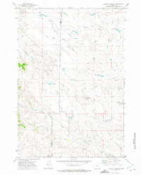
 1972 Rockypoint1975 Print · USGSThe northern Wyoming borderlands come into focus in the early 1970s, showing a landscape defined by ranching and oil exploration. Genealogists and local historians can locate the Rockypoint settlement, Rockypoint Church, and the Nebraska School among the draws of the Little Missouri River.
 - 1972 Map of Flag Butte, 1976 Print
 1972 Flag Butte1976 Print · USGSThe high Wyoming plains at the Campbell and Crook county line were a hub of energy exploration in the early seventies. Genealogists and historians can locate the Wagonhammer Ranch or trace the many drill holes and oil wells near Flag Butte.2 unique versions available
 - 1974 Map of Gillette, 1993 Print
 1974 Gillette1993 Print · USGSGillette and the Powder River Basin are captured here in the mid-seventies during a pivotal era of energy development. Genealogists and historians can trace the early footprint of the Wyodak Strip Mines and the rail-side growth of Rozet and Wyodak.
 - 1975 Map of Recluse, 1977 Print
 1975 Recluse1977 Print · USGSNorthwestern Wyoming ranching country is captured here in the mid-1970s as the high plains meet the Montana border. Genealogists and historians can trace small settlements like Recluse and Spotted Horse, or locate the Burlington Northern rail line near Croton.2 unique versions available
 - 1979 Map of Sundance
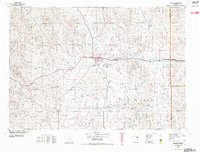
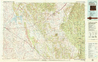 1979 Sundance1979 Print · USGSThe Black Hills borderlands in the late 1970s show a region of high peaks and vital rail corridors connecting Wyoming to South Dakota. Researchers can trace historic routes and industry through settlements like Clay Spur, Upton, and the Historical Monument.2 unique versions available
 - 1979 Map of Devils Tower
 1979 Devils Tower1979 Print · USGSThe High Plains meet the Black Hills in the late 1970s, where the landmark Devils Tower rises above the Belle Fourche River. Trace the Chicago and North Western rail line and locate old outposts like Aladdin and Hulett.2 unique versions available
End of results
Showing maps 1-14 of 14
Top cities of Crook County
- Sundance historical maps
- Moorcroft historical maps
- Pine Haven historical maps
- Hulett historical maps
- Beulah historical maps
Frequently asked questions
- What are the different types of historical maps available for Crook County?
- What is the oldest map of Crook County?
- Where can I purchase historical maps of Crook County for my home or office?
- Where can I download high-res historical maps of Crook County?
- Are there historical topographic maps available for Crook County?
- Is there historical aerial imagery available for Crook County?
- Where are historical maps of Crook County sourced from?