1980s Maps of Crook County, Wyoming
Explore 58 historic maps of Crook County from the 1980s. These maps offer a rare glimpse into what life looked like during the 1980s — showing old roads, neighborhoods, homes, and landmarks that have changed or disappeared over time.
Whether you're researching your family's past, planning a metal detecting trip, or studying how Crook County's landscape evolved across the 1980s, these high-resolution maps are a powerful tool for exploring the history of this region.
- Focus on a specific era: All maps on this page are from the 1980s, giving you a focused view of this time period.
- See what’s changed: Compare century-old streets, trails, and buildings to today's modern landscape using overlays and satellite layers.
- Research with precision: Use these maps for genealogy, historical research, land use analysis, or educational projects.
- View, download, or print: Maps are fully viewable online in high resolution, and can be downloaded or printed for your own records.
Start exploring Crook County's history through authentic maps from the 1980s. This is your window into the past.
Crook County, WY maps
(58)- 1980 Map of Broadus
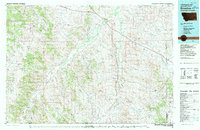 1980 Broadus1980 Print · USGSSoutheastern Montana and the Wyoming borderlands are captured in the early 1980s, centered on the high plains and river breaks of the Powder River. Genealogists and historians can trace old ranching outposts like Moorhead, Epsie, and Biddle alongside landmarks like the Two Tree Mine.
 - 1981 Map of Alzada, 1982 Print
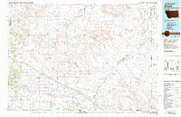 1981 Alzada1982 Print · USGSThe high plains of the Montana-Wyoming borderland appear here in the early eighties as a network of isolated ranches and creek drainages. Genealogists and historians can trace family-named sites like Ridgway and Albion or locate landmarks such as the Sky Ranch and the Claypits.
 - 1982 Map of Spyglass Hill
 1982 Spyglass Hill1982 Print · USGSCrook and Weston County ranchlands meet the Wyoming oil patch in the early eighties. Researchers can trace the development of the Coyote Creek Oil Field and the Burlington Northern rail line near Spyglass Hill.
 - 1982 Map of Freda Creek
 1982 Freda Creek1982 Print · USGSThe energy frontier of northeast Wyoming comes into focus here in the early 1980s. Trace the industrial landscape of the Kara Oil Field and the Burlington Northern railroad alongside Freda Creek and Wind Creek.
 - 1984 Map of Slaughter Reservoir
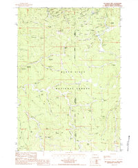
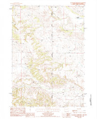 1984 Slaughter Reservoir1984 Print · USGSThe high plains of the South Dakota and Wyoming border come into focus in the mid-1980s, showcasing a landscape of uranium mining and cattle ranching. Trace family legacies at Budmayr Ranch and Massie Ranch or follow the waters of Hay Creek to The Forks.
 - 1984 Map of Buckhorn
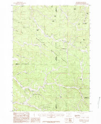 1984 Buckhorn1984 Print · USGSThe Black Hills highlands at the Wyoming and South Dakota border are captured here in the early 1980s. Researchers can locate the Hardy Campus, the settlement of Buckhorn, and numerous family-named landmarks like McInerney Spring.2 unique versions available
 - 1984 Map of Old Baldy Mtn
 1984 Old Baldy Mtn1984 Print · USGSThe Black Hills high country on the South Dakota and Wyoming border comes alive in this mid-eighties survey of mining and ranching territory. Genealogists and researchers can trace family-named sites like Mathews Ranch and the Tinton settlement, or locate historic workings such as the Arctic No 2 Mine.
 - 1984 Map of Moskee
 1984 Moskee1984 Print · USGSCrook County ranching and resource management are documented here during the early eighties, showcasing a landscape of high ridges and hidden springs. Researchers can trace the layout of Reynolds Ranch, the waters of Moskee Creek, and landmarks like Schoolhouse Gulch.
 - 1984 Map of Inyan Kara Mountain
 1984 Inyan Kara Mountain1984 Print · USGSThe Black Hills high country of Northeast Wyoming is captured here in the mid-1980s, centered on the prominent Inyan Kara Mountain. Genealogists and historians can trace the headwaters of Kara Creek and Skull Creek near landmarks like Mount Tom and Star Butte.
 - 1984 Map of Sheldon Creek
 1984 Sheldon Creek1984 Print · USGSCrook and Weston Counties come together in this mid-1980s survey of the Wyoming foothills, showing a landscape defined by the prominent Divide. Researchers can trace the seasonal drainage patterns of Inyan Kara Creek, Skull Creek, and the isolated reaches of Wildcat Canyon.
 - 1984 Map of Middle Creek Butte
 1984 Middle Creek Butte1984 Print · USGSThe high plains of the Wyoming-South Dakota border are captured here in the early 1980s, showcasing an era of heavy clay mining and ranching. Researchers can trace the industrial footprint of numerous Claypit sites or locate family landmarks like the Tope Ranch and McLeod Ranch near the Belle Fourche River.
 - 1984 Map of Red Canyon Creek
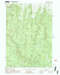
 1984 Red Canyon Creek1984 Print · USGSCrook County ranching and conservation lands come into focus during the mid-eighties, centered on the intersection of the national forest and family homesteads. Researchers can trace land use through the Ranch A National Fish Genetics Laboratory and several historic ranch sites like George Ranch and Bush Ranch.
 - 1984 Map of Arrowhead Reservoir
 1984 Arrowhead Reservoir1984 Print · USGSThe high ridges of northeastern Wyoming appear here in the mid-1980s, revealing a landscape of remote draws and vital water improvements. Researchers can trace land use through the CB&Q Reservoir, the Clay Pit, and family-named landmarks like Fredrickson Draw.2 unique versions available
 - 1984 Map of Gravel Draw
 1984 Gravel Draw1984 Print · USGSThe high plains of the tri-state border region are mapped here in the early eighties, showing the convergence of Wyoming, Montana, and South Dakota. Researchers can locate remote family outposts like Geisinger Ranch and industrial landmarks such as the Claypit near Crow Creek.
 - 1984 Map of Aladdin
 1984 Aladdin1984 Print · USGSAladdin and the surrounding Wyoming ranchlands are captured in the early 1980s, showcasing a landscape defined by mineral extraction and water management. Researchers can locate the Four Oaks Sch., trace the Coal Land Ridge, and identify numerous local Claypits.
 - 1984 Map of Shepard Reservoir
 1984 Shepard Reservoir1984 Print · USGSThe ranchlands of the Montana and Wyoming border are captured here in the mid-1980s, illustrating the remote drainage systems of the high plains. Researchers can locate early family holdings like Crogo Ranch and Newland Ranch or trace the path of the Belle Fourche River.
 - 1984 Map of Beulah
 1984 Beulah1984 Print · USGSThe Wyoming-South Dakota borderlands come alive in this mid-eighties survey of the high plains and Black Hills. Genealogists and local historians can trace the area's development through landmarks like the Beulah townsite, the Cem, and the Mc Nenny National Fish Hatchery.2 unique versions available
 - 1984 Map of Thornton
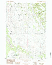
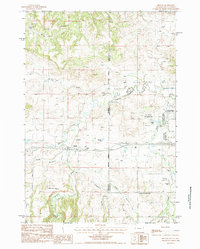
 1984 Thornton1984 Print · USGSThe Crook County and Weston County borderlands are shown here in the mid-1980s, highlighting a landscape of resource extraction and high plains ridges. Genealogists and historians can trace the development of Thornton and locate industrial landmarks like the OIL FIELD and BENTONITE PITS.
 - 1984 Map of Kruger Lake
 1984 Kruger Lake1984 Print · USGSCrook County ranching and mining operations are captured in detail during the mid-eighties as the industry shaped the Belle Fourche valley. Genealogists and historians can locate family holdings like Mule Shoe Ranch and trace the Chicago and North Western rail line through Colony.
 - 1984 Map of Schoolmarm Butte
 1984 Schoolmarm Butte1984 Print · USGSNortheastern Wyoming's ranching and forest lands are captured here in the early eighties, where the Black Hills meet the open range. Researchers can trace land use at Ripley Ranch and locate landmarks like Schoolmarm Butte and Stotts Spring.
 - 1984 Map of Tinton
 1984 Tinton1984 Print · USGSHigh in the Black Hills during the mid-eighties, this map details the intersection of early mining history and federal land management. Researchers can locate the Bear Gulch Cem and dozens of historic workings like the Eureka No 2 Mine and Giant Mine.2 unique versions available
 - 1984 Map of Dry Draw
 1984 Dry Draw1984 Print · USGSThe high plains of Northeast Wyoming meet the forested edge of the Black Hills in the mid-1980s. Researchers can trace the drainage of Inyan Kara Creek across Canyon Springs Prairie and locate landmarks like the Lookout Tower and Henderson Spring.
 - 1984 Map of Black Hills, 1985 Print
 1984 Black Hills1985 Print · USGSCrook County ranchlands and timbered ridges are captured here in the mid-eighties as the forest service managed the high country. Researchers can trace family-named landmarks like Massengale Flats, locate several prospect sites, or find secluded water sources like Togus Spring.2 unique versions available
 - 1984 Map of Seely, 1985 Print
 1984 Seely1985 Print · USGSCrook County ranching life is well-documented in the 1980s as the landscape transitions toward the Black Hills. Researchers can trace remote homesteads and landmarks like Seely, Tromble Ranch Airfield, and the high point at Lovers Leap.
 - 1984 Map of Grasshopper Butte, 1985 Print
 1984 Grasshopper Butte1985 Print · USGSCrook County, Wyoming, is captured in the mid-1980s as the landscape balances recreation at Keyhole Reservoir with active mining operations. Genealogists and researchers can trace local landmarks like Grasshopper Butte and numerous Bentonite Pits near Mule Creek.
Showing maps 1-25 of 58
Top cities of Crook County
- Sundance historical maps
- Moorcroft historical maps
- Pine Haven historical maps
- Hulett historical maps
- Beulah historical maps
Frequently asked questions
- What are the different types of historical maps available for Crook County?
- What is the oldest map of Crook County?
- Where can I purchase historical maps of Crook County for my home or office?
- Where can I download high-res historical maps of Crook County?
- Are there historical topographic maps available for Crook County?
- Is there historical aerial imagery available for Crook County?
- Where are historical maps of Crook County sourced from?