1900-1909 Maps of Johnson County, Wyoming
Explore 5 historic maps of Johnson County from 1900-1909. These maps offer a rare glimpse into what life looked like during the 1900s — showing old roads, neighborhoods, homes, and landmarks that have changed or disappeared over time.
Whether you're researching your family's past, planning a metal detecting trip, or studying how Johnson County's landscape evolved across the 1900s, these high-resolution maps are a powerful tool for exploring the history of this region.
- Focus on a specific era: All maps on this page are from the 1900s, giving you a focused view of this time period.
- See what’s changed: Compare century-old streets, trails, and buildings to today's modern landscape using overlays and satellite layers.
- Research with precision: Use these maps for genealogy, historical research, land use analysis, or educational projects.
- View, download, or print: Maps are fully viewable online in high resolution, and can be downloaded or printed for your own records.
Start exploring Johnson County's history through authentic maps from the 1900s. This is your window into the past.
Johnson County, WY maps
(5)- 1900 Map of Fort McKinney, 1956 Print
 1900 Fort McKinney1956 Print · USGSJohnson County was a landscape of military outposts and early ranching during the 1890s. Researchers can trace the layout of the Fort Mc Kinney Military Reservation or locate family sites like the T A Ranch and Hepp Ranch.
 - 1901 Map of Cloud Peak
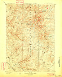 1901 Cloud Peak1901 Print · USGSThe high alpine country of the Big Horn range is captured here at the turn of the century just after its designation as a Forest Reserve. Researchers can trace the rugged headwaters of the Powder River and find remote landmarks like Lake Solitude, Black Butte, and Cloud Peak Lake.7 unique versions available
 - 1901 Map of Dayton
 1901 Dayton1901 Print · USGSSheridan County and the Montana borderlands are captured here at the turn of the century as the railroad reshapes the valley. Researchers can trace early settlements and ranching outposts like Slack, Beckton, and the Morrow Ranch along the Tongue River.5 unique versions available
 - 1903 Map of Fort McKinney
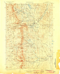 1903 Fort McKinney1903 Print · USGSJohnson County at the turn of the century shows a landscape transitioning from military frontier to a ranching economy. Researchers can locate early family outposts like Trabing, Greub, and the T A Ranch alongside the Fort Mc. Kinney Military Reservation.3 unique versions available
 - 1909 Map of Sheridan, 1954 Print
 1909 Sheridan1954 Print · USGSSheridan and the surrounding northern Wyoming ranchlands are captured here in the first decade of the twentieth century. Genealogists can trace family holdings at Wagoner Ranch or Big Red Ranch, and locate early rail stations like Verona and Ulm.2 unique versions available
End of results
Showing maps 1-5 of 5
Top cities of Johnson County
Frequently asked questions
- What are the different types of historical maps available for Johnson County?
- What is the oldest map of Johnson County?
- Where can I purchase historical maps of Johnson County for my home or office?
- Where can I download high-res historical maps of Johnson County?
- Are there historical topographic maps available for Johnson County?
- Is there historical aerial imagery available for Johnson County?
- Where are historical maps of Johnson County sourced from?