1980s Maps of Johnson County, Wyoming
Explore 11 historic maps of Johnson County from the 1980s. These maps offer a rare glimpse into what life looked like during the 1980s — showing old roads, neighborhoods, homes, and landmarks that have changed or disappeared over time.
Whether you're researching your family's past, planning a metal detecting trip, or studying how Johnson County's landscape evolved across the 1980s, these high-resolution maps are a powerful tool for exploring the history of this region.
- Focus on a specific era: All maps on this page are from the 1980s, giving you a focused view of this time period.
- See what’s changed: Compare century-old streets, trails, and buildings to today's modern landscape using overlays and satellite layers.
- Research with precision: Use these maps for genealogy, historical research, land use analysis, or educational projects.
- View, download, or print: Maps are fully viewable online in high resolution, and can be downloaded or printed for your own records.
Start exploring Johnson County's history through authentic maps from the 1980s. This is your window into the past.
Johnson County, WY maps
(11)- 1981 Map of Midwest
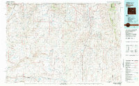 1981 Midwest1981 Print · USGSThe energy-rich plains of central Wyoming are mapped here during the early eighties, highlighting the massive Salt Creek Oil Field. Local historians can trace the rail lines of the Burlington Northern Railroad and locate landmarks like Teapot Rock and the town of Midwest.
 - 1981 Map of Antelope Draw, 1982 Print
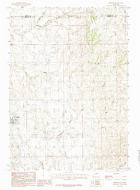
 1981 Antelope Draw1982 Print · USGSThe high plains of Johnson County are shown here in the early eighties, a time of quiet ranching activity. Genealogists and local historians can locate Crain Ranch, Crain Sch, and the topography surrounding Reno Hill.
 - 1982 Map of Lysite
 1982 Lysite1982 Print · USGSCentral Wyoming's high plains and mountain foothills are captured here in the early 1980s, centered on the ranching and rail outposts of Natrona and Fremont Counties. Genealogists and historians can trace the paths of the Burlington Northern and the Old Railroad Grade through Lysite, Lost Cabin, and Arminto.
 - 1984 Map of Edgerton
 1984 Edgerton1984 Print · USGSThe high plains of Natrona County come into focus in the 1980s, centered on the settlement of Edgerton. Researchers can trace the complex network of arid-land drainage systems like Coal Draw, Dead Ford Draw, and the meandering Salt Creek.
 - 1984 Map of Sawmill Canyon
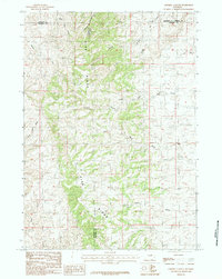 1984 Sawmill Canyon1984 Print · USGSThe high ranching country of east-central Wyoming is shown here in the mid-1980s as it spans four county lines. Researchers can trace the rugged drainage systems of the Pine Ridge including Sawmill Canyon, Wind Creek, and the North Fork Powder R.
 - 1984 Map of Fraker Mountain
 1984 Fraker Mountain1984 Print · USGSJohnson County’s high country is captured here in the 1980s, showcasing a landscape of steep ridges and remote springs. Researchers can trace historic ranching and geography through features like the Stone Corrals, Fraker Pass, and the Red Wall Ditch.
 - 1984 Map of Barnum
 1984 Barnum1984 Print · USGSBarnum and the foothills of the Big Horns appear in this mid-seventies survey of Johnson County. Researchers can trace historical irrigation via the White Panther Ditch or locate landmarks like Castle Rock and the Minecke Trail.
 - 1984 Map of Poker Butte
 1984 Poker Butte1984 Print · USGSThe Powder River forks and the legendary Hole-in-the-Wall country are mapped here during the mid-1980s. Local history researchers can locate ranch sites like Ed O. Taylor and landmarks of the outlaws' era such as Outlaw Cave and the Hole In The Wall Slope.
 - 1984 Map of Packsaddle Canyon
 1984 Packsaddle Canyon1984 Print · USGSJohnson County’s high ranchlands and river canyons are captured in the early 1980s, revealing a landscape of remote mining and water management. Trace old operations like the Top Hand Mine or locate family-named landmarks such as Charlie Brown Springs and Dancehall Flats.
 - 1984 Map of Hole-in-the-wall
 1984 Hole-in-the-wall1984 Print · USGSJohnson County ranchlands are captured in the late seventies, centered on the famous Hole-In-The-Wall pass and the Red Wall escarpment. Local historians can trace the movement of livestock and water through sites like the shearing pens, Bar C Gap, and Buffalo Creek.
 - 1984 Map of The Horn
 1984 The Horn1984 Print · USGSThe high ridges and canyons of Johnson County are shown here in the 1980s, revealing a landscape defined by water rights and ranching infrastructure. Researchers can trace the paths of the Morgareidge Ditch and Coachy Ditch alongside landmarks like Specimen Hill and Dancehall.
End of results
Showing maps 1-11 of 11
Top cities of Johnson County
Frequently asked questions
- What are the different types of historical maps available for Johnson County?
- What is the oldest map of Johnson County?
- Where can I purchase historical maps of Johnson County for my home or office?
- Where can I download high-res historical maps of Johnson County?
- Are there historical topographic maps available for Johnson County?
- Is there historical aerial imagery available for Johnson County?
- Where are historical maps of Johnson County sourced from?