1800s (19th Century) Maps of Teton County, Wyoming
Explore 12 historic maps of Teton County from the 1800s (19th Century). These maps offer a rare glimpse into what life looked like during the 1800s — showing old roads, neighborhoods, homes, and landmarks that have changed or disappeared over time.
Whether you're researching your family's past, planning a metal detecting trip, or studying how Teton County's landscape evolved across the 1800s, these high-resolution maps are a powerful tool for exploring the history of this region.
- Focus on a specific era: All maps on this page are from the 1800s, giving you a focused view of this time period.
- See what’s changed: Compare century-old streets, trails, and buildings to today's modern landscape using overlays and satellite layers.
- Research with precision: Use these maps for genealogy, historical research, land use analysis, or educational projects.
- View, download, or print: Maps are fully viewable online in high resolution, and can be downloaded or printed for your own records.
Start exploring Teton County's history through authentic maps from the 1800s. This is your window into the past.
Teton County, WY maps
(12)- 1885 Map of Lake
 1885 Lake1885 Print · USGSThe high wilderness south of Yellowstone Lake is captured here in the mid-1880s, showcasing the intricate hydrology of the Continental Divide. Researchers can trace the unique split of Pacific Creek and Atlantic Creek at Two Ocean Pass or locate early landmark peaks like The Trident and Mt Stevenson.2 unique versions available
 - 1885 Map of Gallatin
 1885 Gallatin1885 Print · USGSNorthwestern Yellowstone in the 1880s remains a wild expanse of thermal basins and high peaks just as early visitors were beginning to arrive. Geologists and historians can trace the early footprint of Mammoth Hot Springs, the Norris Geyser Basin, and landmarks like Obsidian Cliff.
 - 1885 Map of Gallatin, 1886 Print
 1885 Gallatin1886 Print · USGSEarly park visitors and naturalists can trace the frontier-era geothermal landscape as it was first recorded in the mid-1880s. Identify original landmarks like the Hotel at Mammoth Hot Springs and the early topography of Norris Geyser Basin or Obsidian Cliff.2 unique versions available
 - 1886 Map of Shoshone
 1886 Shoshone1886 Print · USGSYellowstone's thermal wilderness comes to life in the 1880s, documenting the early park era when the Old Faithful Hotel stood as a rare sign of habitation. Trace the geothermal basins and high peaks from Giant Geyser to Mt Sheridan.
 - 1886 Map of Canyon
 1886 Canyon1886 Print · USGSThe Grand Canyon of the Yellowstone area appears here in the late nineteenth century, just over a decade after the park's founding. Modern researchers can locate early landmarks like Yanceys, the Baronette Bridge, and the site of the Fossil Forest.
 - 1888 Map of Shoshone, 1896 Print
 1888 Shoshone1896 Print · USGSYellowstone’s hydrothermal wonders are meticulously charted in the 1880s, shortly after the park's founding. Researchers can trace the earliest mapped geysers and springs, from the Old Faithful Hotel to the remote Shoshone Geyser Basin and Mt Sheridan.
 - 1895 Map of Shoshone
 1895 Shoshone1895 Print · USGSYellowstone at the end of the nineteenth century reveals the early footprint of American conservation and tourism. Researchers can trace the original trails and thermal clusters of the Upper Geyser Basin, including the Old Faithful Hotel and Lone Star Geyser.
 - 1895 Map of Canyon
 1895 Canyon1895 Print · USGSYellowstone's early park architecture and geothermal wonders are captured here in the late nineteenth century. Trace early routes past the Baronett Bridge, the Hotel on the lake, and the storied settlement at Yanceys.
 - 1895 Map of Lake
 1895 Lake1895 Print · USGSSoutheastern Yellowstone was a wild frontier of high passes and glacial lakes in the 1890s. Trace the complex alpine terrain around Yellowstone Lake, the waters of Heart Lake, and notable peaks like Mt Stevenson or Eagle Peak.
 - 1896 Map of Lake
 1896 Lake1896 Print · USGSThe high wilderness of the Wyoming Rockies is captured here in the late nineteenth century, just years after the park's establishment. Researchers can trace the wild southern reaches of Yellowstone Lake and find remote landmarks like Hawks Rest, Bridger Lake, and Brimstone Basin.
 - 1896 Map of Canyon
 1896 Canyon1896 Print · USGSYellowstone National Park is documented in the mid-1890s, capturing the early landmarks and hydrothermal features of the canyon country. Trace the early outposts at Yanceys or the Hotel and locate thermal sites like Calcite Springs and the Fossil Forest.2 unique versions available
 - 1899 Map of Grand Teton, 1954 Print
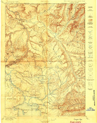
 1899 Grand Teton1954 Print · USGSThe Teton Range and the Snake River valley appear here at the turn of the century, just as early settlers and ranchers were establishing roots in the basin. Researchers can trace historic homesteads like the Cunningham Ranch and Grovont, or locate early structures such as Teton Lodge.
End of results
Showing maps 1-12 of 12
Top cities of Teton County
Frequently asked questions
- What are the different types of historical maps available for Teton County?
- What is the oldest map of Teton County?
- Where can I purchase historical maps of Teton County for my home or office?
- Where can I download high-res historical maps of Teton County?
- Are there historical topographic maps available for Teton County?
- Is there historical aerial imagery available for Teton County?
- Where are historical maps of Teton County sourced from?