1980s Maps of Teton County, Wyoming
Explore 52 historic maps of Teton County from the 1980s. These maps offer a rare glimpse into what life looked like during the 1980s — showing old roads, neighborhoods, homes, and landmarks that have changed or disappeared over time.
Whether you're researching your family's past, planning a metal detecting trip, or studying how Teton County's landscape evolved across the 1980s, these high-resolution maps are a powerful tool for exploring the history of this region.
- Focus on a specific era: All maps on this page are from the 1980s, giving you a focused view of this time period.
- See what’s changed: Compare century-old streets, trails, and buildings to today's modern landscape using overlays and satellite layers.
- Research with precision: Use these maps for genealogy, historical research, land use analysis, or educational projects.
- View, download, or print: Maps are fully viewable online in high resolution, and can be downloaded or printed for your own records.
Start exploring Teton County's history through authentic maps from the 1980s. This is your window into the past.
Teton County, WY maps
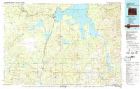
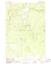
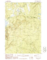
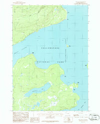
(52)- 1981 Map of Jackson Lake
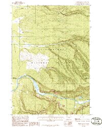
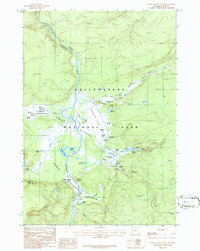
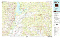 1981 Jackson Lake1981 Print · USGSGrand Teton National Park and its surrounding wilderness are captured here in the early eighties. Researchers can trace high-altitude peaks like Mount Moran down to valley landmarks such as Jackson Lake Lodge, Colter Bay Village, and the Jackson Hole Airport.2 unique versions available
 - 1981 Map of Jackson
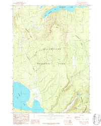
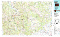 1981 Jackson1981 Print · USGSThe high valleys and peaks surrounding Jackson were undergoing subtle transitions in the early eighties. Genealogists and researchers can trace old mountain outposts like Bondurant, the location of Camp Davis, and the roads leading to Astoria Mineral Hot Springs.
 - 1982 Map of Yellowstone National Park South, 1983 Print
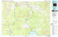
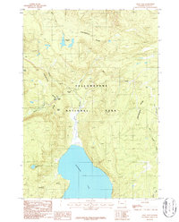
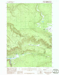
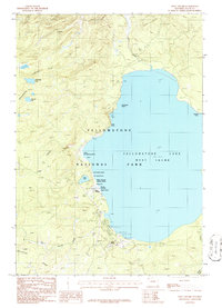
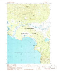
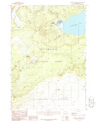
 1982 Yellowstone National Park South1983 Print · USGSThe southern reaches of Yellowstone and the Teton Wilderness are captured here in the early 1980s, showcasing a landscape of high plateaus and river headwaters. Trace the historic paths of the Two Ocean Pass Trail or locate remote outposts like Flagg Ranch and Grant Village.
 - 1983 Map of Yellowstone National Park North
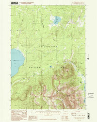
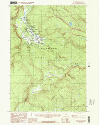
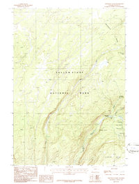
 1983 Yellowstone National Park North1983 Print · USGSThe northern wilderness of Wyoming and Montana is captured here in the early eighties, documenting the geothermal landmarks and early visitor infrastructure. Trace the historic paths of the Howard Eaton Trail or locate park icons like Mammoth Hot Springs and the Lake Hotel.
 - 1986 Map of Jack Straw Basin
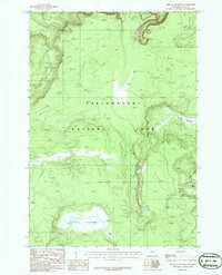
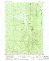
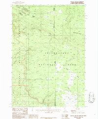
 1986 Jack Straw Basin1986 Print · USGSThe wilderness along the Montana and Wyoming border comes into focus in the mid-1980s, documenting the rugged intersection of two massive federal preserves. Researchers can trace the drainage patterns of Jack Straw Basin and identify remote water features like Big Bear Lake and Frog Pond.
 - 1986 Map of Mount Jackson
 1986 Mount Jackson1986 Print · USGSYellowstone's western interior is documented here in the mid-eighties, centered on the dramatic passage of the Madison River. Historians can trace the winding Pack Trail and identify high-country landmarks like Mount Jackson and Harlequin Lake.
 - 1986 Map of Craig Pass
 1986 Craig Pass1986 Print · USGSYellowstone National Park in the mid-1980s reveals a high-altitude wilderness shaped by the spine of the Rockies. Researchers can trace the unique dual-drainage of Isa Lake at Craig Pass or locate the northern reaches of Shoshone Lake.
 - 1986 Map of Mount Sheridan
 1986 Mount Sheridan1986 Print · USGSThe high backcountry of Yellowstone National Park is captured here in the mid-1980s, centered on the heights of the Red Mountains. Trace the remote Pack Trail network past geothermal features like the Heart Lake Geyser Basin and Rustic Geyser.2 unique versions available
 - 1986 Map of Buffalo Meadows
 1986 Buffalo Meadows1986 Print · USGSYellowstone's backcountry during the mid-1980s comes to life in this detailed provisional survey. Backcountry explorers and historians can trace routes through Buffalo Meadows and Sentinel Meadows, or locate the Imperial Geyser and Twin Buttes.
 - 1986 Map of Summit Lake
 1986 Summit Lake1986 Print · USGSYellowstone's high backcountry comes into focus in the mid-1980s, centered on the headwaters of the Firehole. Trace remote geothermal features like Smoke Jumper Hot Springs and follow the Continental Divide past Summit Lake.
 - 1986 Map of Madison Junction
 1986 Madison Junction1986 Print · USGSYellowstone's central river valleys are captured here in the mid-1980s, documenting the landscape where the Firehole and Gibbon rivers meet. Researchers can trace the layout of Madison Junction, locate the Monument Geyser Basin, and follow the Gibbon Canyon.
 - 1986 Map of Old Faithful
 1986 Old Faithful1986 Print · USGSYellowstone National Park in the mid-eighties reveals the complex infrastructure and geothermal wonders surrounding the world's most famous geyser basin. Trace the density of thermal features like Morning Glory Pool and Biscuit Basin or follow the Pack Trail across the Continental Divide.
 - 1986 Map of Mary Lake
 1986 Mary Lake1986 Print · USGSYellowstone National Park in the mid-eighties was a landscape of high plateaus and remote backcountry trails. You can trace the path of the Pack Trail as it winds past Mary Lake and several Hot Springs along the Nez Perce Creek.
 - 1986 Map of Norris Junction
 1986 Norris Junction1986 Print · USGSYellowstone National Park in the mid-eighties reveals a landscape shaped by geothermal activity and mountain drainages. Researchers can trace the hydrothermal features of Norris Geyser Basin, the Artists Paintpots, and the Chocolate Pots.
 - 1986 Map of Buffalo Lake NE
 1986 Buffalo Lake NE1986 Print · USGSThe high wilderness where Idaho, Montana, and Wyoming meet is captured here in the mid-1980s at the junction of three major protected forests. Trace the Continental Divide as it winds past the headwaters of Black Canyon Creek and Thirsty Creek in Yellowstone National Park.
 - 1986 Map of West Thumb
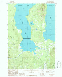
 1986 West Thumb1986 Print · USGSYellowstone National Park in the mid-1980s showcased the developed shoreline of the West Thumb and its famous thermal basins. Researchers can locate specific geothermal features like Thumb Paintpots and Beach Geyser or study the layout of Grant Village.
 - 1986 Map of Frank Island
 1986 Frank Island1986 Print · USGSThe southeastern reaches of Yellowstone Lake are documented in the mid-1980s, detailing a wild landscape of islands and inlets. Researchers can trace the Pack Trail along the shore or locate landmarks like Frank Island and The Promontory.
 - 1986 Map of Trischman Knob
 1986 Trischman Knob1986 Print · USGSYellowstone's wild southwestern corner is captured in the mid-1980s, centered on the river junctions and falls of the Bechler region. Trace the Pack Trail past Three River Junction to find remote landmarks like Tendoy Falls, Wahhi Falls, and Ragged Falls.
 - 1986 Map of Lower Geyser Basin
 1986 Lower Geyser Basin1986 Print · USGSYellowstone National Park is shown in the mid-1980s, focusing on the thermal wonders of the Lower Geyser Basin. Trace the intricate trail and spring networks surrounding Grand Prismatic Spring, Fountain Paint Pot, and Firehole Lake.2 unique versions available
 - 1986 Map of Lake Butte
 1986 Lake Butte1986 Print · USGSYellowstone's thermal landscape and the northeastern shore of the lake are shown in detail during the mid-1980s. Naturalists and researchers can trace geothermal features like Steamboat Springs and Ebro Springs alongside the Pelican Valley.
 - 1986 Map of Buffalo Lake
 1986 Buffalo Lake1986 Print · USGSThe Idaho-Wyoming border comes alive in the mid-1980s where the backcountry of the Teton and Yellowstone wilderness meets. Researchers can trace the remote headwaters of Buffalo Lake, find the high point of Snow Creek Butte, and follow the winding path of Cascade Creek.
 - 1986 Map of Alder Lake
 1986 Alder Lake1986 Print · USGSYellowstone National Park in the mid-1980s reveals a wilderness landscape defined by the branching arms of the great lake. Wilderness travelers can trace the Pack Trail through the Two Ocean Plateau or locate the lone Cabin near Peale Island.
 - 1986 Map of Dot Island
 1986 Dot Island1986 Print · USGSThe Yellowstone backcountry in the mid-eighties reveals a preserved wilderness of interconnected waterways and isolated islands. Researchers can trace the complex shorelines of Delusion Lake, the reaches of Eagle Bay, and the remote Dot Island.
 - 1986 Map of Heart Lake
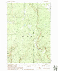
 1986 Heart Lake1986 Print · USGSBackcountry Teton County was a preserved wilderness of high ridges and deep lakes in the mid-1980s. Researchers can trace the winding Continental Divide between Heart Lake and the Flat Mountain Arm of Yellowstone Lake.
 - 1986 Map of Shoshone Geyser Basin
 1986 Shoshone Geyser Basin1986 Print · USGSYellowstone's thermal backcountry and the crest of the Rockies are captured in the mid-eighties as they appeared before the great fires of the era. Researchers can pinpoint specific geothermal vents like Bronze Geyser and Shield Geyser or trace the Continental Divide above Madison Lake.2 unique versions available
Showing maps 1-25 of 52
Top cities of Teton County
Frequently asked questions
- What are the different types of historical maps available for Teton County?
- What is the oldest map of Teton County?
- Where can I purchase historical maps of Teton County for my home or office?
- Where can I download high-res historical maps of Teton County?
- Are there historical topographic maps available for Teton County?
- Is there historical aerial imagery available for Teton County?
- Where are historical maps of Teton County sourced from?