1900s (20th Century) Maps of Teton County, Wyoming
Explore 204 historic maps of Teton County from the 1900s (20th Century). These maps offer a rare glimpse into what life looked like during the 1900s — showing old roads, neighborhoods, homes, and landmarks that have changed or disappeared over time.
Whether you're researching your family's past, planning a metal detecting trip, or studying how Teton County's landscape evolved across the 1900s, these high-resolution maps are a powerful tool for exploring the history of this region.
- Focus on a specific era: All maps on this page are from the 1900s, giving you a focused view of this time period.
- See what’s changed: Compare century-old streets, trails, and buildings to today's modern landscape using overlays and satellite layers.
- Research with precision: Use these maps for genealogy, historical research, land use analysis, or educational projects.
- View, download, or print: Maps are fully viewable online in high resolution, and can be downloaded or printed for your own records.
Start exploring Teton County's history through authentic maps from the 1900s. This is your window into the past.
Teton County, WY maps
(204)- 1901 Map of Canyon
 1901 Canyon1901 Print · USGSYellowstone's northeast wilderness appears at the dawn of the twentieth century, detailing the park's early infrastructure and raw geothermal wonders. Researchers can trace the original locations of Yanceys, Baronett Bridge, and unique curiosities like the Fossil Forest.
 - 1901 Map of Shoshone
 1901 Shoshone1901 Print · USGSYellowstone's geothermal wonders and early park boundaries are detailed here during the late Victorian era. Researchers can trace the early footprint of the Old Faithful Hotel and locate remote hydrothermal sites like Shoshone Geyser Basin and Rustic Geyser.
 - 1901 Map of Gallatin
 1901 Gallatin1901 Print · USGSThe high plateau of the Yellowstone country appears here in the late nineteenth century, just as its hydrothermal wonders were becoming globally known. Researchers can locate early campsites and lodges near the Norris Geyser Basin, Obsidian Cliff, and Mammoth Hot Springs.
 - 1901 Map of Lake
 1901 Lake1901 Print · USGSYellowstone's wilderness at the dawn of the twentieth century is charted here through its complex alpine hydrography and high-altitude peaks. Researchers can trace early park boundaries and remote landmarks like Hawks Rest, Brimstone Basin, and Frank Island.
 - 1901 Map of Grand Teton, 1909 Print
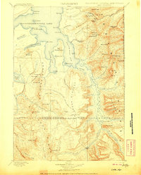
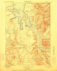
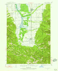
 1901 Grand Teton1909 Print · USGSThe Teton valley was a land of homesteads and river crossings at the turn of the century. Genealogists can trace early settler families at Grovont and numerous holdings like Cunningham Ranch or locate the historic Menor Ferry crossing.4 unique versions available
 - 1902 Map of Mt Leidy
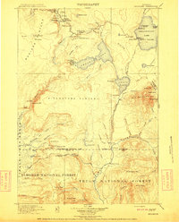
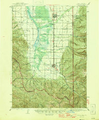
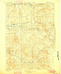 1902 Mt Leidy1902 Print · USGSTeton and Uinta counties are shown here at the turn of the century as a wilderness of forest reserves and high mountain passes. Researchers can trace early routes over the Continental Divide at Twogwotee Pass or locate the remote Dick Turpin Meadow.5 unique versions available
 - 1906 Map of Lake
 1906 Lake1906 Print · USGSThe deep backcountry of Wyoming's wilderness is captured here in the 1880s as the park's southern reaches remained largely untamed. Trace the remote waters of Bridger Lake, the isolated outpost at Hawks Rest, and the hydrological curiosity of Two Ocean Pass.
 - 1907 Map of Canyon
 1907 Canyon1907 Print · USGSYellowstone during the early years of the National Park Service era showcases a landscape defined by geothermal wonders and frontier outposts. Trace the early tourism routes past Yanceys and the Mushpots or locate historic features like Baronett Bridge.
 - 1907 Map of Gros Ventre, 1957 Print
 1907 Gros Ventre1957 Print · USGSRanching life in the Wyoming high country is captured here during the first decade of the century, detailing the homesteads of the Gros Ventre Range. Researchers can trace the legacy of early settlers at Old Kendall and Kendall, or locate family-named landmarks like Loomis Ranch and Twin Creek School.
 - 1908 Map of Gallatin
 1908 Gallatin1908 Print · USGSYellowstone National Park in the early 1900s reveals a wilderness of hydrothermal wonders and early frontier outposts. Trace the locations of original park structures like Fort Yellowstone and thermal landmarks including Norris Geyser Basin and Beryl Spring.
 - 1908 Map of Shoshone
 1908 Shoshone1908 Print · USGSYellowstone's geothermal wonders and early park development appear here during the first decade of the twentieth century. Researchers can trace the trails and landmarks near Old Faithful Hotel and locate remote features like Lone Star Geyser and Shoshone Geyser Basin.
 - 1910 Map of Gros Ventre
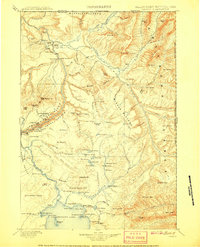
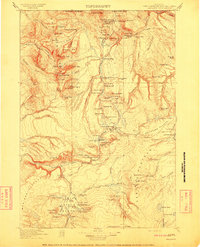
 1910 Gros Ventre1910 Print · USGSThe Gros Ventre Range is shown in the early twentieth century as a network of isolated family homesteads and early forest reserves. Genealogists and historians can trace pioneer roots at Bondurant, Twin Creek School, and Darwin Ranch.3 unique versions available
 - 1911 Map of Lake
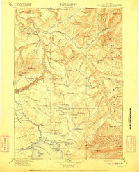
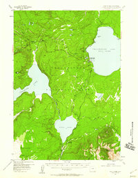
 1911 Lake1911 Print · USGSYellowstone's southeastern wilderness is mapped here in the early twentieth century, showing the remote high plateaus and the intricate arms of the great lake. Researchers can trace the Continental Divide across Two Ocean Pass and locate isolated outposts like Snowshoe Cabin and Hawks Rest.2 unique versions available
 - 1911 Map of Shoshone
 1911 Shoshone1911 Print · USGSThe thermal basins and early back-country outposts of southern Yellowstone are captured here in the early nineteen-hundreds. Trace early tourism and patrol routes through the Shoshone Geyser Basin, the Thumb Hotel, and the Snowshoe Cabin.3 unique versions available
 - 1911 Map of Gallatin
 1911 Gallatin1911 Print · USGSYellowstone's thermal wonders and early military outposts are recorded in detail just after the turn of the century. Researchers can trace the early road and trail systems connecting landmark sites like Fort Yellowstone, the Norris Geyser Basin, and the Fountain Hotel.2 unique versions available
 - 1911 Map of Canyon
 1911 Canyon1911 Print · USGSYellowstone National Park is captured here in the early twentieth century as a fledgling wilderness preserve. Researchers can trace the early road system including the Cooke Road and find historic sites like Yanceys, the Canyon Hotel, and Fishing Bridge.6 unique versions available
 - 1931 Map of Jackson, 1961 Print
 1931 Jackson1961 Print · USGSJackson and the upper Snake River canyon are documented here in the early thirties, showcasing a wilderness era of ranching and forestry. Researchers can trace early outposts like Browns Ranch or locate family history at the Etna Cem and Johnny Counts Flat.
 - 1932 Map of Irwin
 1932 Irwin1932 Print · USGSThe Snake River corridor and the high mountain basins of eastern Idaho are captured here in the early 1930s. Researchers can trace early river crossings like Edwards Ferry or find small-community landmarks like Rainy Dale and Pumpkin Center Sch.2 unique versions available
 - 1935 Map of Irwin
 1935 Irwin1935 Print · USGSThe Idaho-Wyoming borderlands are captured here in the 1930s as the river economy and mountain ranching defined the region. Researchers can trace the early road networks and rural institutions from Edwards Ferry to local schools like Fidelity Sch and Blowout Sch.3 unique versions available
 - 1935 Map of Jackson
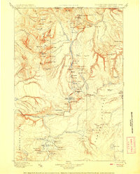
 1935 Jackson1935 Print · USGSThe high valleys of the Teton and Gros Ventre ranges are captured here in the mid-thirties, showing the early infrastructure of the upper Snake River region. Researchers can locate early schools and ranching outposts like Porcupine Sch, Browns Ranch, and the Jackson Mine.2 unique versions available
 - 1943 Map of Driggs, 1955 Print
 1943 Driggs1955 Print · USGSTeton Valley during the mid-forties is depicted as a thriving agricultural and rail corridor between the high peaks of the Teton Mountains. Researchers can trace the heritage of local rural life through labels for Bates Sch, Darby Ch, and the Union Pacific line.3 unique versions available
 - 1946 Map of Driggs
 1946 Driggs1946 Print · USGSThe Teton Valley was a landscape of remote mountain peaks and irrigated ranch land during the mid-forties. Genealogists and historians can trace old homestead sites near Bates Sch and Sorensen or follow the historic Union Pacific rail line between Driggs and Victor.
 - 1955 Map of Ashton, 1967 Print
 1955 Ashton1967 Print · USGSThe Greater Yellowstone ecosystem is captured here during the mid-1950s, showing the high plateaus and remote gateway towns of Idaho and Montana. Researchers can trace the Union Pacific line to Ashton or locate small settlements like Squirrel and Grainville.4 unique versions available
 - 1955 Map of Driggs, 1967 Print
 1955 Driggs1967 Print · USGSEastern Idaho and Western Wyoming appear at a mid-century crossroads as the river valleys were fully settled and the high peaks protected. Genealogists and researchers can trace the rail towns of Rexburg and Driggs or follow the Snake River from Irwin to the Palisades Reservoir.3 unique versions available
 - 1956 Map of West Thumb, 1958 Print
 1956 West Thumb1958 Print · USGSYellowstone National Park in the mid-1950s reveals a high-country landscape of geyser basins and glacial lakes. Trace backcountry trails to the Aster Creek Patrol Cabin or explore the hydrothermal activity at Rustic Geyser and the Thumb Paintpots.3 unique versions available
Showing maps 1-25 of 204
Top cities of Teton County
Frequently asked questions
- What are the different types of historical maps available for Teton County?
- What is the oldest map of Teton County?
- Where can I purchase historical maps of Teton County for my home or office?
- Where can I download high-res historical maps of Teton County?
- Are there historical topographic maps available for Teton County?
- Is there historical aerial imagery available for Teton County?
- Where are historical maps of Teton County sourced from?