1950s Maps of Teton County, Wyoming
Explore 18 historic maps of Teton County from the 1950s. These maps offer a rare glimpse into what life looked like during the 1950s — showing old roads, neighborhoods, homes, and landmarks that have changed or disappeared over time.
Whether you're researching your family's past, planning a metal detecting trip, or studying how Teton County's landscape evolved across the 1950s, these high-resolution maps are a powerful tool for exploring the history of this region.
- Focus on a specific era: All maps on this page are from the 1950s, giving you a focused view of this time period.
- See what’s changed: Compare century-old streets, trails, and buildings to today's modern landscape using overlays and satellite layers.
- Research with precision: Use these maps for genealogy, historical research, land use analysis, or educational projects.
- View, download, or print: Maps are fully viewable online in high resolution, and can be downloaded or printed for your own records.
Start exploring Teton County's history through authentic maps from the 1950s. This is your window into the past.
Teton County, WY maps
(18)- 1955 Map of Ashton, 1967 Print
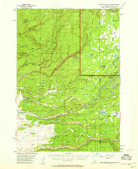
 1955 Ashton1967 Print · USGSThe Greater Yellowstone ecosystem is captured here during the mid-1950s, showing the high plateaus and remote gateway towns of Idaho and Montana. Researchers can trace the Union Pacific line to Ashton or locate small settlements like Squirrel and Grainville.4 unique versions available
 - 1955 Map of Driggs, 1967 Print
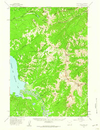
 1955 Driggs1967 Print · USGSEastern Idaho and Western Wyoming appear at a mid-century crossroads as the river valleys were fully settled and the high peaks protected. Genealogists and researchers can trace the rail towns of Rexburg and Driggs or follow the Snake River from Irwin to the Palisades Reservoir.3 unique versions available
 - 1956 Map of West Thumb, 1958 Print
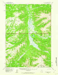
 1956 West Thumb1958 Print · USGSYellowstone National Park in the mid-1950s reveals a high-country landscape of geyser basins and glacial lakes. Trace backcountry trails to the Aster Creek Patrol Cabin or explore the hydrothermal activity at Rustic Geyser and the Thumb Paintpots.3 unique versions available
 - 1956 Map of Old Faithful, 1958 Print
 1956 Old Faithful1958 Print · USGSYellowstone's geothermal heart is captured during the mid-fifties, centered on the active basins of the Firehole River. Trace the early layout of the Old Faithful Inn or follow backcountry routes to the Lone Star Geyser and Shoshone Lake.2 unique versions available
 - 1956 Map of Grassy Lake Reservoir, 1959 Print
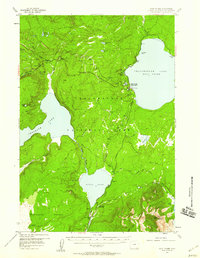
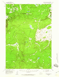
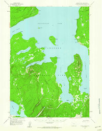
 1956 Grassy Lake Reservoir1959 Print · USGSThe wild intersection of Yellowstone and the Grand Tetons is captured here during the mid-fifties. Researchers can trace remote trails and landmarks like Porter Ranch, Grassy Lake Reservoir, and the waters of the Bechler River.4 unique versions available
 - 1956 Map of Huckleberry Mountain, 1959 Print
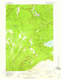
 1956 Huckleberry Mountain1959 Print · USGSThe convergence of Wyoming’s great national parks is captured here in the mid-1950s, detailing the wild terrain between the Yellowstone and Grand Teton boundaries. Trace early backcountry routes like the South Boundary Trail to landmarks like Flagg Ranch and Moose Falls.3 unique versions available
 - 1957 Map of Warm River Butte, 1958 Print
 1957 Warm River Butte1958 Print · USGSEastern Idaho and the edge of Yellowstone are mapped here in the late fifties, showing a remote landscape of high-country ranches and federal forest outposts. Genealogists and historians can trace the locations of the Kelly School, Howell Ranch, and the Old Marysville Road.3 unique versions available
 - 1957 Map of Buffalo Lake, 1959 Print
 1957 Buffalo Lake1959 Print · USGSHigh in the northern Rockies during the late fifties, the borders of Idaho, Montana, and Wyoming meet along the high spine of the Continental Divide. Trace the remote wilderness of the Madison Plateau and locate isolated landmarks like the Patrol Cabin or Latham Spring.2 unique versions available
 - 1958 Map of Driggs
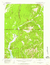
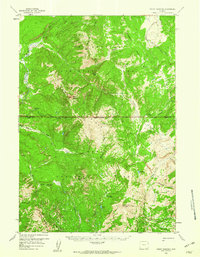
 1958 Driggs1958 Print · USGSThe high Teton peaks and Snake River valleys are captured here in the mid-fifties, showing the region's agricultural and wilderness boundaries. Researchers can trace the Union Pacific rail corridor through Rexburg or locate early settlements like Clementsville and Tetonia.2 unique versions available
 - 1958 Map of Ashton
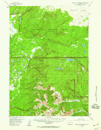
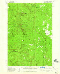
 1958 Ashton1958 Print · USGSGreater Yellowstone and the eastern Idaho borderlands appear here in the mid-1950s as rail and road networks connected remote mountain basins. Trace the Union Pacific route through Ashton or locate early outposts like Last Chance, Squirrel, and West Yellowstone.
 - 1958 Map of Madison Junction, 1959 Print
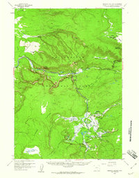 1958 Madison Junction1959 Print · USGSYellowstone's geothermal heart is captured here in the late fifties, centered on the confluence of the Firehole and Gibbon rivers. Researchers can locate specific hydrothermal features like Grand Prismatic Spring or trace the early paths of the Howard Eaton Trail and Freight Road.2 unique versions available
 - 1958 Map of West Yellowstone, 1960 Print
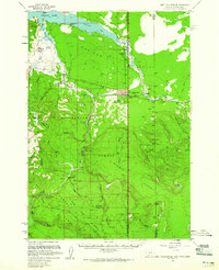 1958 West Yellowstone1960 Print · USGSWest Yellowstone and the surrounding national forests are captured here in the late fifties, just before a major earthquake altered the region. Researchers can trace early park access via the Union Pacific and locate remote outposts like Whitmans Cabin and the Basin Ranger Sta.3 unique versions available
 - 1958 Map of Norris Junction, 1960 Print
 1958 Norris Junction1960 Print · USGSYellowstone National Park is captured in the late fifties, showcasing the intricate hydrothermal activity and early ranger outposts of the interior. Researchers can trace historic park infrastructure like the Norris Museum and the remote Mary Lake Patrol Cabin.3 unique versions available
 - 1959 Map of Mount Hancock, 1960 Print
 1959 Mount Hancock1960 Print · USGSThe Wyoming backcountry at the boundary of Yellowstone and Teton National Forest is shown here during the late fifties. Trace the remote ranger network at Harebell Creek Patrol Cabin, Fox Park Patrol Cabin, and the Two Ocean Trail.3 unique versions available
 - 1959 Map of Two Ocean Pass, 1960 Print
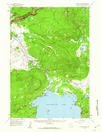
 1959 Two Ocean Pass1960 Print · USGSTeton County and the high Yellowstone wilderness are captured here in the late fifties, showcasing the remote headwaters of major Western rivers. Follow the historic Continental Divide Trail past landmarks like Bridger Lake and the Thorofare Ranger Station.4 unique versions available
 - 1959 Map of Canyon Village, 1960 Print
 1959 Canyon Village1960 Print · USGSYellowstone's central interior is captured in the late fifties, showcasing the early hospitality centers and thermal landmarks of the national park. Researchers can trace mid-century tourism routes through Canyon Village, Lake Hotel, and the famed Inspiration Point.2 unique versions available
 - 1959 Map of Eagle Peak, 1960 Print
 1959 Eagle Peak1960 Print · USGSYellowstone's rugged eastern interior and the Shoshone National Forest are captured in this late 1950s survey of the Absaroka Range. Trace high-altitude backcountry routes over Eagle Pass and locate remote outposts like the Cabin Creek Patrol Cabin or East Entrance Ranger Station.3 unique versions available
 - 1959 Map of Frank Island, 1960 Print
 1959 Frank Island1960 Print · USGSYellowstone National Park in the late fifties shows the remote southern reaches of the lake and its complex shoreline. Backcountry researchers can trace historic routes like the Snake River Trail and locate isolated outposts including the Park Pt Patrol Cabin.3 unique versions available
End of results
Showing maps 1-18 of 18
Top cities of Teton County
Frequently asked questions
- What are the different types of historical maps available for Teton County?
- What is the oldest map of Teton County?
- Where can I purchase historical maps of Teton County for my home or office?
- Where can I download high-res historical maps of Teton County?
- Are there historical topographic maps available for Teton County?
- Is there historical aerial imagery available for Teton County?
- Where are historical maps of Teton County sourced from?