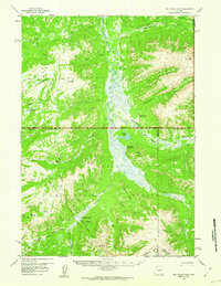
1959 Map of Two Ocean Pass
USGS Topo · Published 1960About this map
Two Ocean Pass serves as a geographic centerpiece for this high-altitude wilderness, where the Continental Divide dictates the drainage of the American West. The map documents the intricate hydrology of the upper Yellowstone River and Thorofare River basins within Yellowstone National Park and the adjacent Teton National Forest. Notable landmarks such as the Thorofare Ranger Station and Hawks Rest Patrol Cabin mark remote outposts in a landscape dominated by peaks and plateaus. The drainage pattern is unique, particularly at the pass where waters part toward the Atlantic and Pacific oceans via Atlantic Creek and Pacific Creek. A network of historic paths, including the Continental Divide Trail and the Atlantic-Pacific Trail, provides the primary means of traversal through this roadless territory as it was surveyed in the late 1950s.
Find a feature on this map
47 named features on this map. Tap any name to fly to it.
Don’t see what you’re looking for? This feature index may not catch every label — zoom into the map to look around manually.
Map Details
Editions of this 1959 Two Ocean Pass Map
4 editions found
Other maps of this area

1885 · Lake
USGS Topo · 1:125,000

1893 · Ishawooa
USGS Topo · 1:125,000

1895 · Ishawooa
USGS Topo · 1:125,000

1895 · Lake
USGS Topo · 1:125,000

1896 · Lake
USGS Topo · 1:125,000

1899 · Ishawooa
USGS Topo · 1:125,000

1901 · Lake
USGS Topo · 1:125,000

1902 · Mt Leidy
USGS Topo · 1:125,000

1905 · Younts Peak
USGS Topo · 1:125,000

1906 · Lake
USGS Topo · 1:125,000