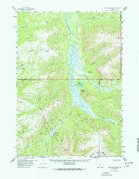
1959 Map of Two Ocean Pass
USGS Topo · Published 1977About this map
Two Ocean Pass serves as a remarkable hydrological landmark within Teton National Forest, where North American waters split toward two different oceans. This 1959 field-checked survey captures the intricate drainage patterns of the Continental Divide, specifically where Atlantic Creek and Pacific Creek emerge from the same marshy meadow. The landscape is defined by the headwaters of the Yellowstone River and the Snake River, connected by an extensive network of primitive paths including the Thorofare Trail and various unnamed pack trails. Evidence of early wilderness management is visible at the Thorofare Ranger Station and Hawks Rest Patrol Cabin. The map highlights the intersection of several county boundaries, including Teton, Park, and Fremont, while documenting the massive Two Ocean Plateau and prominent heights like Hawks Rest and Yellowstone Point.
Find a feature on this map
40 named features on this map. Tap any name to fly to it.
Don’t see what you’re looking for? This feature index may not catch every label — zoom into the map to look around manually.
Map Details
Editions of this 1959 Two Ocean Pass Map
4 editions found
Other maps of this area

1885 · Lake
USGS Topo · 1:125,000

1893 · Ishawooa
USGS Topo · 1:125,000

1895 · Ishawooa
USGS Topo · 1:125,000

1895 · Lake
USGS Topo · 1:125,000

1896 · Lake
USGS Topo · 1:125,000

1899 · Ishawooa
USGS Topo · 1:125,000

1901 · Lake
USGS Topo · 1:125,000

1902 · Mt Leidy
USGS Topo · 1:125,000

1905 · Younts Peak
USGS Topo · 1:125,000

1906 · Lake
USGS Topo · 1:125,000