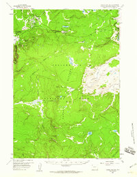
1958 Map of Norris Junction
USGS Topo · Published 1960About this map
Norris Geyser Basin serves as the focal point of this late 1950s survey, illustrating the complex thermal landscape of northwestern Yellowstone National Park. The map documents early park infrastructure at Norris Junction, including the Norris Ranger Sta and the Norris Museum, alongside the legendary hydrothermal features of the Gibbon Geyser Basin. To the south and east, the wilderness of the Central Plateau and the open expanses of Hayden Valley are detailed with their primitive backcountry routes.
Find a feature on this map
58 named features on this map. Tap any name to fly to it.
Don’t see what you’re looking for? This feature index may not catch every label — zoom into the map to look around manually.
Map Details
Editions of this 1958 Norris Junction Map
3 editions found
Other maps of this area

1885 · Lake
USGS Topo · 1:125,000

1885 · Gallatin
USGS Topo · 1:125,000

1885 · Gallatin
USGS Topo · 1:125,000

1886 · Shoshone
USGS Topo · 1:125,000

1886 · Canyon
USGS Topo · 1:125,000

1888 · Shoshone
USGS Topo · 1:125,000

1895 · Shoshone
USGS Topo · 1:125,000

1895 · Canyon
USGS Topo · 1:125,000

1895 · Lake
USGS Topo · 1:125,000

1896 · Lake
USGS Topo · 1:125,000