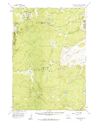
1958 Map of Norris Junction
USGS Topo · Published 1986About this map
Thermal activity and backcountry outposts define this portion of Yellowstone National Park during the late 1950s. At the northern end, Norris Junction serves as a primary hub, containing the Norris Ranger Sta and the Norris Museum adjacent to the active Norris Geyser Basin. The map captures the complex geothermal landscape in detail, from the Echinus Geyser and One Hundred Spring Plain to the Artists Paintpots within the Gibbon Geyser Basin.
Find a feature on this map
53 named features on this map. Tap any name to fly to it.
Don’t see what you’re looking for? This feature index may not catch every label — zoom into the map to look around manually.
Map Details
Editions of this 1958 Norris Junction Map
3 editions found
Other maps of this area

1885 · Lake
USGS Topo · 1:125,000

1885 · Gallatin
USGS Topo · 1:125,000

1885 · Gallatin
USGS Topo · 1:125,000

1886 · Shoshone
USGS Topo · 1:125,000

1886 · Canyon
USGS Topo · 1:125,000

1888 · Shoshone
USGS Topo · 1:125,000

1895 · Shoshone
USGS Topo · 1:125,000

1895 · Canyon
USGS Topo · 1:125,000

1895 · Lake
USGS Topo · 1:125,000

1896 · Lake
USGS Topo · 1:125,000