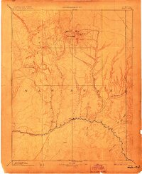
1893 Map of Abajo
USGS Topo · Published 1908About this map
Bluff City stands as the primary settlement on this 1890s reconnaissance, established along the banks of the San Juan River in southeastern Utah. The map documents a rugged landscape defined by massive relief, where the Abajo Mts rise to prominent summits at Mt Linnaeus and Abajo Peak. To the north, the historic Old Spanish Trail traverses the high country, while the southern boundary is marked by the Navajo Indian Res. Line. The drainage patterns here are distinct, with numerous seasonal watercourses like Montezuma Creek, Recapture Creek, and Comb Wash cutting deep into the desert floor. This survey, conducted by Henry Gannett and the Hayden Surveys, provides an early look at the territorial geography before the widespread development of the Four Corners region, capturing the intricate topography of Chin Lee Valley and the prominent Orejas del Oso ridges.
Find a feature on this map
23 named features on this map. Tap any name to fly to it.
Don’t see what you’re looking for? This feature index may not catch every label — zoom into the map to look around manually.
Map Details
Editions of this 1893 Abajo Map
5 editions found

Other maps of this area

1883 · Marsh Pass
USGS Topo · 1:250,000

1885 · San Rafael
USGS Topo · 1:250,000

1885 · La Sal
USGS Topo · 1:250,000

1886 · Henry Mountains
USGS Topo · 1:250,000

1886 · Abajo
USGS Topo · 1:250,000

1889 · Chaco
USGS Topo · 1:250,000

1892 · Marsh Pass
USGS Topo · 1:250,000

1892 · Abajo
USGS Topo · 1:250,000

1892 · Henry Mountains
USGS Topo · 1:250,000

1892 · Chaco
USGS Topo · 1:250,000