
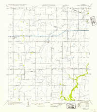
1932 Map of Abbeville NW
USGS Topo · Published 1932About this map
Abbeville serves as the focal point of this coastal prairie landscape, where the winding course of Vermilion Bayou dictates the local geography and transport patterns. In the early 1930s, the region was defined by a transition from traditional water-based transit to an expanding network of rail and road, evidenced by the Southern Pacific tracks and numerous State Highway No 25 segments. The interior is heavily marked by an intricate irrigation system including the Abbeville Canal, Austin Canal, and Ward Canal, illustrating the engineering required to manage the wetlands for agricultural use. Local community life is preserved through the locations of the Moutons Cove Sch, Briggs Chapel, and the river crossing at Bancker Ferry, providing a rare look at the rural social structure before modern consolidation. Smaller settlements like Perry, Theall, and Nunez are connected by coulees such as Dick Hunter Coulee and Tanya Coulee.
Find a feature on this map
37 named features on this map. Tap any name to fly to it.
Don’t see what you’re looking for? This feature index may not catch every label — zoom into the map to look around manually.
Map Details
Editions of this 1932 Abbeville NW Map
This is the sole edition of this map. No revisions or reprints were ever made.
Other maps of this area

1932 · Abbeville SW
USGS Topo · 1:31,680

1932 · Abbeville SE
USGS Topo · 1:31,680

1932 · Abbeville NE
USGS Topo · 1:31,680

1946 · Milton
USGS Topo · 1:31,680

1946 · Schooner Bayou SE
USGS Topo · 1:31,680

1946 · Leroy
USGS Topo · 1:31,680

1946 · Schooner Bayou NE
USGS Topo · 1:31,680

1946 · Kaplan
USGS Topo · 1:31,680

1952 · Lake Charles
USGS Topo · 1:250,000
1954 · Leroy
USGS Topo · 1:31,680