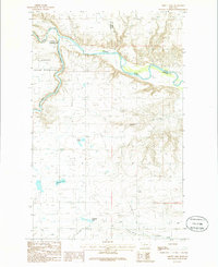
1985 Map of Abbott Lake
USGS Topo · Published 1986About this map
The Marias River and the Two Medicine River converge within this mid-1980s topographic study, marking a landscape of significant hydraulic and administrative boundaries. Part of the Blackfeet Indian Reservation is visible in the western portion of the map, where the terrain is punctuated by steep breaks and Coulees leading down to the river valleys. The hydrology of the region is defined by a complex network of man-made and natural features, including an extensive Canal system, the Stetler Lakes, and Abbott Lake. Small-scale industrial activity is evidenced by a Gravel Pit located near the northern river bend. This survey captures the rural character of the Montana plains at a time when traditional water resources and modern irrigation infrastructure like the A H Canal and Bullhead Springs shaped the settlement patterns around the locality of Abbott.
Find a feature on this map
15 named features on this map. Tap any name to fly to it.
Don’t see what you’re looking for? This feature index may not catch every label — zoom into the map to look around manually.
Map Details
Editions of this 1985 Abbott Lake Map
This is the sole edition of this map. No revisions or reprints were ever made.
Other maps of this area

1907 · Blackfoot Res.
USGS Topo · 1:48,000

1909 · Cut Bank
USGS Topo · 1:125,000

1912 · Cut Bank
USGS Topo · 1:125,000

1920 · Dupuyer
USGS Topo · 1:125,000

1934 · Lake Frances
USGS Topo · 1:48,000

1934 · Valier
USGS Topo · 1:62,500

1937 · Valier
USGS Topo · 1:62,500

1937 · Lake Frances
USGS Topo · 1:62,500

1960 · Cut Bank
USGS Topo · 1:250,000

1963 · Cut Bank
USGS Topo · 1:250,000