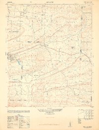
1948 Map of Abbott
USGS Topo · Published 1948About this map
Mansfield and Abbott anchor this postwar survey of the Arkansas borderlands between Sebastian and Scott Counties. The landscape is defined by a series of parallel ridges, including Black Jack Ridge, Coop Ridge, and Gibson Ridge, which channel the various branches of Prairie Creek and the headwaters of the Petit Jean Creek. This era of the late 1940s shows a rural society still tied closely to its local institutions, evidenced by the distribution of the Crossroads School and multiple small burial grounds like Cantrell Cemetery and Union Ridge Cem. The northern reach of the Ouachita National Forest covers the southern portion of the quadrangle, while the St. Louis-San Francisco Railway (ST L & S F) provides a critical transit link for the communities and local industry, including a Sawmill located near the Logan County line.
Find a feature on this map
49 named features on this map. Tap any name to fly to it.
Don’t see what you’re looking for? This feature index may not catch every label — zoom into the map to look around manually.
Map Details
Editions of this 1948 Abbott Map
4 editions found
Other maps of this area

1879 · Poteau Mountain
USGS Topo · 1:62,500

1887 · Poteau Mountain #1
USGS Topo · 1:62,500

1887 · Poteau Mountain #2
USGS Topo · 1:62,500

1887 · Greenwood
USGS Topo · 1:62,500

1890 · Fort Smith
USGS Topo · 1:125,000

1890 · Poteau Mountain
USGS Topo · 1:125,000

1899 · Poteau Mountain
USGS Topo · 1:125,000

1906 · Barber
USGS Topo · 1:62,500

1939 · Waldron
USGS Topo · 1:62,500

1940 · Waldron
USGS Topo · 1:62,500