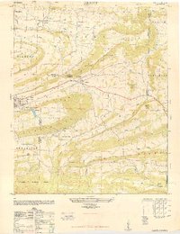
1948 Map of Abbott
USGS Topo · Published 1948About this map
Abbott and Mansfield serve as central points in this mid-century portrait of western Arkansas, where the landscape is defined by a series of prominent ridgelines including Black Jack Ridge and Coop Ridge. The Rock Island railroad corridor cuts through the valley, anchoring a rural economy that supported small settlements like Dayton and Pine Grove Valley. The map reveals the intricate drainage system of the area, from Petit Jean Creek in the south to Little Washburn Creek in the north.
Find a feature on this map
42 named features on this map. Tap any name to fly to it.
Don’t see what you’re looking for? This feature index may not catch every label — zoom into the map to look around manually.
Map Details
Editions of this 1948 Abbott Map
4 editions found
Other maps of this area

1879 · Poteau Mountain
USGS Topo · 1:62,500

1887 · Poteau Mountain #1
USGS Topo · 1:62,500

1887 · Poteau Mountain #2
USGS Topo · 1:62,500

1887 · Greenwood
USGS Topo · 1:62,500

1890 · Fort Smith
USGS Topo · 1:125,000

1890 · Poteau Mountain
USGS Topo · 1:125,000

1899 · Poteau Mountain
USGS Topo · 1:125,000

1906 · Barber
USGS Topo · 1:62,500

1939 · Waldron
USGS Topo · 1:62,500

1940 · Waldron
USGS Topo · 1:62,500