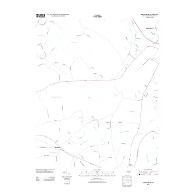
2013 Map of Abbottsburg
USGS Topo · Published 2013About this map
Brown Marsh Swamp dominates the lower central portion of this Bladen County landscape, reflecting the intricate drainage patterns of the Carolina coastal plain. To the southwest, the community of Abbottsburg sits at a junction of historic roads, while the northern edge reaches the outskirts of Elizabethtown. This 2013 survey illustrates a region defined by agricultural infrastructure and water management, visible in the straight lines of the Marsh Canal and Bryant Swamp Canal. The map reveals a network of rural routes named for local families and landmarks, such as Clayton Pait Rd, Sarah Merritt Rd, and Hester Mill Rd. Smaller watercourses like Whites Cr and Mill Race provide a detailed look at the local hydrography, showing how the natural swamps have been navigated and utilized for generations in eastern North Carolina.
Find a feature on this map
83 named features on this map. Tap any name to fly to it.
Don’t see what you’re looking for? This feature index may not catch every label — zoom into the map to look around manually.
Map Details
Editions of this 2013 Abbottsburg Map
This is the sole edition of this map. No revisions or reprints were ever made.
Other maps of this area

1953 · Chadbourn
USGS Topo · 1:62,500

1953 · Florence
USGS Topo · 1:250,000

1954 · Florence
USGS Topo · 1:250,000

1955 · Whiteville
USGS Topo · 1:62,500

1955 · Elizabethtown
USGS Topo · 1:62,500

1957 · Bladenboro
USGS Topo · 1:62,500

1982 · Elizabethtown
USGS Topo · 1:100,000

1986 · Whiteville
USGS Topo · 1:100,000

1986 · Tar Heel
USGS Topo · 1:24,000
1986 · Bladenboro
USGS Topo · 1:24,000