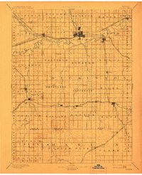
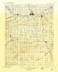
1894 Map of Abilene
USGS Topo · Published 1908About this map
The Smoky Hill River and Solomon River converge in the western half of this Kansas landscape, forming a natural hub for early settlement and transportation. In this late nineteenth-century survey, the town of Abilene stands as a significant rail center, served by the Union Pacific Railroad and the Atchison Topeka and Santa Fe R.R.. The map illustrates a highly organized grid of townships such as Wheatland, Jefferson, and Logan, reflecting the region's agricultural foundations.
Find a feature on this map
84 named features on this map. Tap any name to fly to it.
Don’t see what you’re looking for? This feature index may not catch every label — zoom into the map to look around manually.
Map Details
Editions of this 1894 Abilene Map
6 editions found

Other maps of this area

1886 · Junction City
USGS Topo · 1:125,000

1889 · Newton
USGS Topo · 1:125,000

1889 · Junction City
USGS Topo · 1:125,000

1889 · Abilene
USGS Topo · 1:125,000

1889 · Parkerville
USGS Topo · 1:125,000

1891 · Hutchinson
USGS Topo · 1:125,000

1891 · Clay Center
USGS Topo · 1:125,000

1892 · Salina
USGS Topo · 1:125,000

1892 · Minneapolis
USGS Topo · 1:125,000

1893 · Hutchinson
USGS Topo · 1:125,000