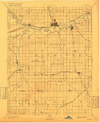
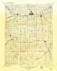
1894 Map of Abilene
USGS Topo · Published 1917About this map
The confluence of the Solomon River and the Smoky Hill River anchors this late-nineteenth-century landscape, which was surveyed as a central Kansas rail hub just decades after the region's cattle-town boom. Abilene and Enterprise emerge as major points of interest, dense with development along the Union Pacific Railroad. The map reveals a complex grid of smaller rail lines and stations like Detroit and Solomon, reflecting the rapid expansion of the grain-based economy. Beyond the river valleys, the terrain is divided into survey townships such as Wheatland, Newbern, and Durham Park, where smaller settlements like Navarre and Hope served as local agricultural centers. The detailed rendering of Turkey Creek and Chapman Cr. shows how the hydrography dictated the layout of the townships and the subsequent placement of the many competing railroad branches that crisscrossed Dickinson County.
Find a feature on this map
78 named features on this map. Tap any name to fly to it.
Don’t see what you’re looking for? This feature index may not catch every label — zoom into the map to look around manually.
Map Details
Editions of this 1894 Abilene Map
6 editions found

Other maps of this area

1886 · Junction City
USGS Topo · 1:125,000

1889 · Newton
USGS Topo · 1:125,000

1889 · Junction City
USGS Topo · 1:125,000

1889 · Abilene
USGS Topo · 1:125,000

1889 · Parkerville
USGS Topo · 1:125,000

1891 · Hutchinson
USGS Topo · 1:125,000

1891 · Clay Center
USGS Topo · 1:125,000

1892 · Salina
USGS Topo · 1:125,000

1892 · Minneapolis
USGS Topo · 1:125,000

1893 · Hutchinson
USGS Topo · 1:125,000