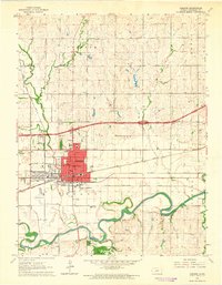
1964 Map of Abilene
USGS Topo · Published 1965About this map
The Abilene city center serves as the hub of this mid-century Kansas landscape, characterized by its dense grid of schools like Garfield Sch and public landmarks such as the Eisenhower Center. This 1964 field-checked map illustrates a critical crossroads for American rail, where the Atchison Topeka and Santa Fe, Union Pacific, and Chicago Rock Island and Pacific railroads all converge near the heart of town. Beyond the residential core, the geography is defined by the winding path of the Smoky Hill River to the south, bordered by community sites like Brown Memorial Park and the Brown Memorial Home. Small outlying settlements such as Detroit and Enterprise are shown connected by the river valley and rail lines, while aviation is represented by both the Abilene Airport and the smaller Wright Airpark.
Find a feature on this map
38 named features on this map. Tap any name to fly to it.
Don’t see what you’re looking for? This feature index may not catch every label — zoom into the map to look around manually.
Map Details
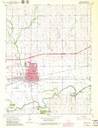
Editions of this 1964 Abilene Map
2 editions found
Other maps of this area

1889 · Abilene
USGS Topo · 1:125,000

1891 · Clay Center
USGS Topo · 1:125,000

1894 · Abilene
USGS Topo · 1:125,000

1955 · Manhattan
USGS Topo · 1:250,000

1955 · Hutchinson
USGS Topo · 1:250,000

1956 · Manhattan
USGS Topo · 1:250,000

1957 · Manhattan
USGS Topo · 1:250,000

1959 · Hutchinson
USGS Topo · 1:250,000
1963 · Upland
USGS Topo · 1:24,000

1963 · Abilene SW
USGS Topo · 1:24,000