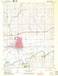
1964 Map of Abilene
USGS Topo · Published 1980About this map
Abilene serves as a significant rail and civic hub where the Union Pacific, Chicago Rock Island and Pacific, and Atchison Topeka and Santa Fe railroads converge. The map reflects the community's mid-century expansion and its deep ties to its most famous resident, featuring the Eisenhower Center at the heart of the city. Beyond the urban grid of streets like Buckeye St and Mulberry St, the landscape is defined by the winding course of the Smoky Hill River, which forms the boundary for townships such as Grant and Center. Local institutions like the Brown Memorial Home and Garfield Sch are clearly marked, alongside essential infrastructure including the Abilene Municipal Airport and various quarries and sandpits that indicate the area's local industrial activity.
Find a feature on this map
52 named features on this map. Tap any name to fly to it.
Don’t see what you’re looking for? This feature index may not catch every label — zoom into the map to look around manually.
Map Details
Editions of this 1964 Abilene Map
2 editions found
Other maps of this area

1889 · Abilene
USGS Topo · 1:125,000

1891 · Clay Center
USGS Topo · 1:125,000

1894 · Abilene
USGS Topo · 1:125,000

1955 · Manhattan
USGS Topo · 1:250,000

1955 · Hutchinson
USGS Topo · 1:250,000

1956 · Manhattan
USGS Topo · 1:250,000

1957 · Manhattan
USGS Topo · 1:250,000

1959 · Hutchinson
USGS Topo · 1:250,000
1963 · Upland
USGS Topo · 1:24,000

1963 · Abilene SW
USGS Topo · 1:24,000