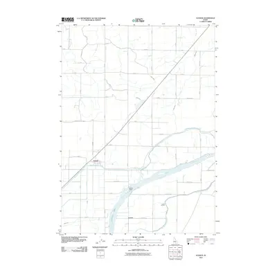
2010 Map of Acequia
USGS Topo · Published 2010About this map
The Snake River anchors this agricultural landscape in Minidoka County, serving as the central artery for a complex network of irrigation infrastructure. This 2010 survey highlights the critical water management systems of the region, where the Main North Side Canal and Main South Side Canal distribute water across the plains to support local farming operations. The town of Acequia sits at a strategic junction near several major canals, reflecting the area's development around water access and transportation.
Find a feature on this map
44 named features on this map. Tap any name to fly to it.
Don’t see what you’re looking for? This feature index may not catch every label — zoom into the map to look around manually.
Map Details
Editions of this 2010 Acequia Map
This is the sole edition of this map. No revisions or reprints were ever made.
Other maps of this area

1954 · Pocatello
USGS Topo · 1:250,000

1958 · Pocatello
USGS Topo · 1:250,000

1959 · Lake Walcott
USGS Topo · 1:62,500

1964 · Rupert SE
USGS Topo · 1:24,000

1964 · Rupert NW
USGS Topo · 1:24,000

1964 · Acequia
USGS Topo · 1:24,000

1964 · Rupert SW
USGS Topo · 1:24,000

1972 · Minidoka
USGS Topo · 1:24,000

1972 · Max
USGS Topo · 1:24,000
1972 · Norland
USGS Topo · 1:24,000