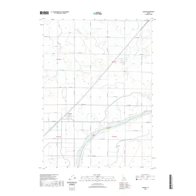
2020 Map of Acequia
USGS Topo · Published 2020About this map
Acequia sits at the heart of an intricate agricultural landscape defined by the complex water management systems of the Snake River Plain. The town is bordered to the south by the Main North Side Canal, while the Snake River itself cuts through the lower portion of the map, serving as the border between Minidoka County and Cassia County. This area reflects a highly organized irrigation economy, where every section of land is integrated into a network of drains and canals, such as the B Main Drain, C Main Drain, and Main South Side Canal. Near the river, the settlement of Jackson and the nearby Jackson Cem mark a smaller focal point of local history, connected across the water by the Jackson Bridge. The geometry of the landscape is dictated by a rigid grid of roads like Gravity Canal Rd and 900 North Rd, illustrating how early twentieth-century reclamation projects transformed this high desert into productive farmland.
Find a feature on this map
55 named features on this map. Tap any name to fly to it.
Don’t see what you’re looking for? This feature index may not catch every label — zoom into the map to look around manually.
Map Details
Editions of this 2020 Acequia Map
This is the sole edition of this map. No revisions or reprints were ever made.
Other maps of this area

1954 · Pocatello
USGS Topo · 1:250,000

1958 · Pocatello
USGS Topo · 1:250,000

1959 · Lake Walcott
USGS Topo · 1:62,500

1964 · Rupert SE
USGS Topo · 1:24,000

1964 · Rupert NW
USGS Topo · 1:24,000

1964 · Acequia
USGS Topo · 1:24,000

1964 · Rupert SW
USGS Topo · 1:24,000

1972 · Minidoka
USGS Topo · 1:24,000

1972 · Max
USGS Topo · 1:24,000
1972 · Norland
USGS Topo · 1:24,000