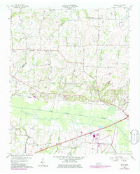
1959 Map of Adair
USGS Topo · Published 1979About this map
The South Fork Forked Deer River dominates the southern landscape of this West Tennessee region, where the border of Crockett and Madison counties meets. Small agricultural communities such as Adair, Midway, and Windy City are linked by a network of historic transit corridors, including the Gulf Illinois Central Railroad and the Jackson-Bells Highway. The map reveals a dense concentration of local institutions essential to rural life in the late 1950s, particularly the numerous country schools and churches like Mason Grove Sch and Bascom Ch. Genealogists will find significant value in the scattered family-named cemeteries, such as the Hicks Cem and McLemore Cem, which mark the homesteads and legacies of long-established residents near Poplar Corner and Bethlehem.
Find a feature on this map
67 named features on this map. Tap any name to fly to it.
Don’t see what you’re looking for? This feature index may not catch every label — zoom into the map to look around manually.
Map Details
Editions of this 1959 Adair Map
4 editions found
Other maps of this area

1950 · Jackson South
USGS Topo · 1:24,000

1950 · Jackson North
USGS Topo · 1:24,000

1951 · Jackson North
USGS Topo · 1:24,000

1956 · Blytheville
USGS Topo · 1:250,000

1959 · Medina
USGS Topo · 1:24,000

1959 · Blytheville
USGS Topo · 1:250,000

1959 · Bells
USGS Topo · 1:24,000

1959 · Westover
USGS Topo · 1:24,000

1959 · Denmark
USGS Topo · 1:24,000

1959 · Adair
USGS Topo · 1:24,000