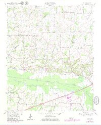
1959 Map of Adair
USGS Topo · Published 1979About this map
The South Fork Forked Deer River cuts a wide swath of bottomland through this West Tennessee landscape, separating the rural communities of Adair and Mason Grove from the growing outskirts of Jackson. Mapping in the late 1950s with late 1970s updates shows a transition from traditional cotton-country settlements to modern infrastructure. Numerous family-named cemeteries such as Hicks Cem, De Loach Cem, and McLemore Cem reflect long-standing ties to the land, while the Illinois Central Gulf Railroad corridor and Old Highway 70 represent the primary transportation arteries of the era. Smaller rural nodes like Windy City and Poplar Corner remain centered around community landmarks like Poplar Corner Ch, providing a detailed view of the county's social geography before late-twentieth-century suburban expansion reached the Jackson Corp Bdry.
Find a feature on this map
44 named features on this map. Tap any name to fly to it.
Don’t see what you’re looking for? This feature index may not catch every label — zoom into the map to look around manually.
Map Details
Editions of this 1959 Adair Map
4 editions found
Other maps of this area

1950 · Jackson South
USGS Topo · 1:24,000

1950 · Jackson North
USGS Topo · 1:24,000

1951 · Jackson North
USGS Topo · 1:24,000

1956 · Blytheville
USGS Topo · 1:250,000

1959 · Medina
USGS Topo · 1:24,000

1959 · Blytheville
USGS Topo · 1:250,000

1959 · Bells
USGS Topo · 1:24,000

1959 · Westover
USGS Topo · 1:24,000

1959 · Denmark
USGS Topo · 1:24,000

1959 · Adair
USGS Topo · 1:24,000