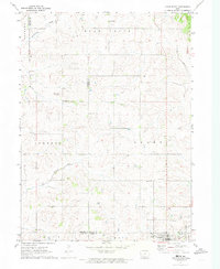
1971 Map of Adair North
USGS Topo · Published 1973About this map
Adair sits at the southern edge of this West Central Iowa landscape, where three counties—Audubon, Guthrie, and Adair—meet in a complex of rural townships including Bear Grove and Grant. The terrain is defined by the winding paths of Troublesome Creek, Crooked Creek, and the Middle River, which carve through the agricultural uplands. Evidence of former transportation networks is visible in the Old RR Grade running near the southern boundary, a feature of significant interest to those tracing the evolution of the regional rail economy. Local history is anchored by several rural landmarks, such as Kenfield, New Bethel Church, and the Townhall. For genealogists, the map provides precise locations for St Johns Cemetery, Pleasant Hill Cemetery, and Immanuel Cemetery, preserving the placement of these community cornerstones as they appeared in the early 1970s.
Find a feature on this map
25 named features on this map. Tap any name to fly to it.
Don’t see what you’re looking for? This feature index may not catch every label — zoom into the map to look around manually.
Map Details
Editions of this 1971 Adair North Map
This is the sole edition of this map. No revisions or reprints were ever made.
Other maps of this area

1954 · Omaha
USGS Topo · 1:250,000

1957 · Omaha
USGS Topo · 1:250,000

1957 · Audubon
USGS Topo · 1:62,500

1958 · Omaha
USGS Topo · 1:250,000

1971 · Adair South
USGS Topo · 1:24,000

1971 · Anita
USGS Topo · 1:24,000

1971 · Canby
USGS Topo · 1:24,000

1971 · North Branch
USGS Topo · 1:24,000

1971 · Casey
USGS Topo · 1:24,000

1971 · Guthrie Center West
USGS Topo · 1:24,000