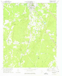
1972 Map of Adairsville
USGS Topo · Published 1975About this map
Adairsville serves as the primary hub in this northwest Georgia landscape, where the Louisville and Nashville railroad corridor dictates the pattern of valley settlement. The map traces a complex network of ridges including Swain Mountain, Kitchens Mountain, and Snow Springs Mtn, which funnel numerous watercourses like Oothkalooga Creek and Connesena Creek toward the south.
Find a feature on this map
55 named features on this map. Tap any name to fly to it.
Don’t see what you’re looking for? This feature index may not catch every label — zoom into the map to look around manually.
Map Details
Editions of this 1972 Adairsville Map
This is the sole edition of this map. No revisions or reprints were ever made.
Other maps of this area

1886 · Rome
USGS Topo · 1:125,000

1890 · Cartersville
USGS Topo · 1:125,000

1891 · Cartersville
USGS Topo · 1:125,000

1896 · Cartersville
USGS Topo · 1:125,000

1898 · Rome
USGS Topo · 1:125,000

1899 · Rome
USGS Topo · 1:125,000

1904 · Rome
USGS Topo · 1:125,000

1906 · Stilesboro
USGS Topo · 1:62,500

1908 · Stilesboro
USGS Topo · 1:62,500

1941 · Adairsville
USGS Topo · 1:62,500