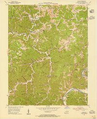
1953 Map of Adams
USGS Topo · Published 1955About this map
The Oil Field dominates the northern reaches of this Lawrence County landscape, where numerous wells are scattered across the ridges and hollows north of Little Blaine Creek. The terrain is deeply dissected by a network of waterways including the Right Fork and Left Fork of the creek, which dictated the settlement patterns of early 1950s Appalachia. Small communities and family centers such as Evergreen, Adams, and Ledocio are connected by winding roads that follow the valley floors, while prominent ridges like Dry Ridge and Pleasant Ridge provide elevated landmarks.
Find a feature on this map
115 named features on this map. Tap any name to fly to it.
Don’t see what you’re looking for? This feature index may not catch every label — zoom into the map to look around manually.
Map Details
Editions of this 1953 Adams Map
2 editions found
Other maps of this area

1886 · Prestonsburg
USGS Topo · 1:125,000

1892 · Prestonsburg
USGS Topo · 1:125,000

1903 · Kenova
USGS Topo · 1:125,000

1904 · Kenova
USGS Topo · 1:125,000

1911 · Louisa
USGS Topo · 1:48,000

1913 · Louisa
USGS Topo · 1:62,500

1914 · Inez
USGS Topo · 1:48,000

1915 · Paintsville
USGS Topo · 1:48,000

1916 · Inez
USGS Topo · 1:62,500

1917 · Paintsville
USGS Topo · 1:62,500