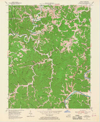
1953 Map of Adams
USGS Topo · Published 1968About this map
Blaine Creek and the Levisa Fork dominate the rugged geography of this eastern Kentucky landscape, which in the early 1950s was defined by small hill settlements and an active extractive economy. Numerous oil fields are indicated across the north, while Strip Mines appear along the southeastern reaches near McClure. The social fabric of Lawrence County is anchored by rural landmarks like Carters Chapel and Moores Chapel, alongside small schoolhouses such as the Blackburn Sch and Dry Ridge Sch. Transportation follows the winding river valleys, with the Chesapeake and Ohio railroad skirting the southern banks of the Levisa Fork through Beech Farm. Genealogists will find a wealth of family names preserved in sites like Adkins Cem, Moore Cem, and Shannon Cem, providing a precise record of local residency before modern redevelopment.
Find a feature on this map
112 named features on this map. Tap any name to fly to it.
Don’t see what you’re looking for? This feature index may not catch every label — zoom into the map to look around manually.
Map Details
Editions of this 1953 Adams Map
2 editions found
Other maps of this area

1886 · Prestonsburg
USGS Topo · 1:125,000

1892 · Prestonsburg
USGS Topo · 1:125,000

1903 · Kenova
USGS Topo · 1:125,000

1904 · Kenova
USGS Topo · 1:125,000

1911 · Louisa
USGS Topo · 1:48,000

1913 · Louisa
USGS Topo · 1:62,500

1914 · Inez
USGS Topo · 1:48,000

1915 · Paintsville
USGS Topo · 1:48,000

1916 · Inez
USGS Topo · 1:62,500

1917 · Paintsville
USGS Topo · 1:62,500