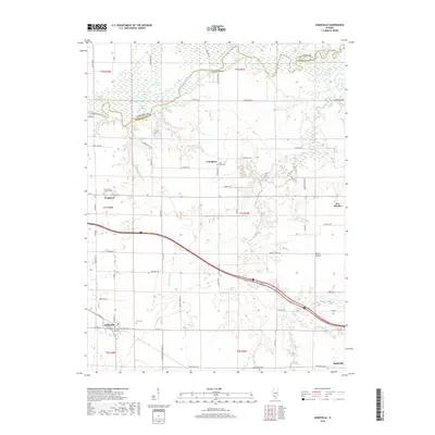
2018 Map of Addieville
USGS Topo · Published 2018About this map
The Kaskaskia River winds across the northern border of this Illinois landscape, defining the boundary between Clinton and Washington counties. This river corridor is marked by a complex network of wetlands and oxbow lakes, including Big Forked Lake, Horseshoe Lake, and Turkey Lake. To the south, the terrain transitions into a grid of agricultural land and small rural communities. Addieville serves as a local hub, situated near the headwaters of Plum Creek, while smaller settlements like Frogtown, Lively, and New Minden are scattered throughout the quadrangle. Several historic burial grounds, such as Olive Branch Lutheran Cem and Saint Lukes Cem, provide anchor points for genealogical research. The infrastructure is characterized by a mix of established roads with avian-themed names like Cardinal Rd and Bluebird Rd, alongside the long-standing Covington Bridge crossing the river.
Find a feature on this map
80 named features on this map. Tap any name to fly to it.
Don’t see what you’re looking for? This feature index may not catch every label — zoom into the map to look around manually.
Map Details
Editions of this 2018 Addieville Map
This is the sole edition of this map. No revisions or reprints were ever made.
Other maps of this area

1906 · Breese
USGS Topo · 1:62,500

1907 · Breese
USGS Topo · 1:62,500

1910 · Carlyle
USGS Topo · 1:62,500

1910 · Okawville
USGS Topo · 1:62,500

1931 · Hoyleton
USGS Topo · 1:48,000

1932 · Nashville
USGS Topo · 1:62,500

1936 · Nashville
USGS Topo · 1:62,500

1940 · Okawville
USGS Topo · 1:62,500

1948 · Carlyle
USGS Topo · 1:62,500

1958 · Belleville
USGS Topo · 1:250,000