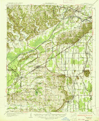
1934 Map of Advance
USGS Topo · Published 1934About this map
Advance sits at the nexus of a highly engineered landscape in Southeast Missouri, where the rugged hills of the north meet the reclaimed lowlands of the Bootheel. The transformation of this terrain is evident through the massive Headwater Diversion Channel and an intricate network of numbered ditches like Ditch No 26 and Ditch No 34, designed to drain the swampy basins for agriculture. The St Louis San Francisco Railway and the St Louis Southwestern Railway provide the vital transit links between small rail towns such as Bell City, Whitewater, and Arbor. Scattered throughout these rural townships are centers of community life, including the Toga No 2 Sch, Trinity Ch, and the Cruse Cem. The map captures the region after significant drainage projects were underway but before modern highway expansion, preserving a view of early 20th-century Missouri land management.
Find a feature on this map
92 named features on this map. Tap any name to fly to it.
Don’t see what you’re looking for? This feature index may not catch every label — zoom into the map to look around manually.
Map Details
Editions of this 1934 Advance Map
3 editions found
Other maps of this area

1922 · Cape Girardeau
USGS Topo · 1:62,500

1924 · Cape Girardeau
USGS Topo · 1:62,500

1931 · Sikeston
USGS Topo · 1:62,500

1933 · Marble Hill
USGS Topo · 1:62,500

1933 · Marquand
USGS Topo · 1:62,500

1934 · Morley
USGS Topo · 1:62,500

1934 · Bloomfield
USGS Topo · 1:62,500

1934 · Sikeston
USGS Topo · 1:62,500

1934 · Advance
USGS Topo · 1:62,500

1934 · Puxico
USGS Topo · 1:62,500