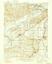
1934 Map of Advance
USGS Topo · Published 1950About this map
The Headwater Diversion Channel cuts a bold diagonal across this landscape, illustrating the massive hydrological engineering required to drain the Missouri Bootheel for agriculture. The map captures the transition of the lowlands from swamps into a highly structured grid of drainage ditches, such as Ditch No 109 and Ditch No 287, which redefined the geography of Stoddard and Cape Girardeau counties.
Find a feature on this map
93 named features on this map. Tap any name to fly to it.
Don’t see what you’re looking for? This feature index may not catch every label — zoom into the map to look around manually.
Map Details
Editions of this 1934 Advance Map
3 editions found
Other maps of this area

1922 · Cape Girardeau
USGS Topo · 1:62,500

1924 · Cape Girardeau
USGS Topo · 1:62,500

1931 · Sikeston
USGS Topo · 1:62,500

1933 · Marble Hill
USGS Topo · 1:62,500

1933 · Marquand
USGS Topo · 1:62,500

1934 · Morley
USGS Topo · 1:62,500

1934 · Bloomfield
USGS Topo · 1:62,500

1934 · Sikeston
USGS Topo · 1:62,500

1934 · Advance
USGS Topo · 1:62,500

1934 · Puxico
USGS Topo · 1:62,500