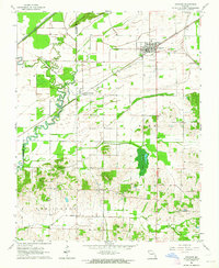
1963 Map of Advance
USGS Topo · Published 1964About this map
Advance serves as the primary hub of this corner of Stoddard County in the early 1960s, situated where the St Louis - San Francisco railroad meets the lowlands. The landscape transition is stark, moving from the northern Goose Pond Hills down into a plain managed by the Diversion Channel and Tilley Ditch. These drainage features, along with the Castor River, define the agricultural character of the region during this era.
Find a feature on this map
28 named features on this map. Tap any name to fly to it.
Don’t see what you’re looking for? This feature index may not catch every label — zoom into the map to look around manually.
Map Details
Editions of this 1963 Advance Map
This is the sole edition of this map. No revisions or reprints were ever made.
Other maps of this area

1934 · Bloomfield
USGS Topo · 1:62,500

1934 · Advance
USGS Topo · 1:62,500

1934 · Puxico
USGS Topo · 1:62,500

1935 · Zalma
USGS Topo · 1:62,500

1939 · Bloomfield
USGS Topo · 1:62,500

1939 · Advance
USGS Topo · 1:62,500

1939 · Puxico
USGS Topo · 1:62,500

1939 · Zalma
USGS Topo · 1:62,500

1949 · Paducah
USGS Topo · 1:250,000

1949 · Rolla
USGS Topo · 1:250,000