
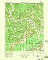
1939 Map of Zalma
USGS Topo · Published 1943About this map
The Castor River meanders through the heart of the eastern Ozark foothills, defining the landscape around Zalma and its neighboring rural settlements. During the late 1930s, this region was a crossroads of both active and fading transportation networks, seen in the presence of the St Louis Memphis Division rail lines and a notable segment labeled Abandoned near Greenbrier. The map documents a dense network of small community institutions that served the scattered population of the time, including dozens of local schools like Fish Sch and Shady Dell Sch.
Find a feature on this map
96 named features on this map. Tap any name to fly to it.
Don’t see what you’re looking for? This feature index may not catch every label — zoom into the map to look around manually.
Map Details
Editions of this 1939 Zalma Map
2 editions found
Other maps of this area

1930 · Coldwater
USGS Topo · 1:62,500

1933 · Marble Hill
USGS Topo · 1:62,500

1933 · Marquand
USGS Topo · 1:62,500

1934 · Greenville
USGS Topo · 1:62,500

1934 · Bloomfield
USGS Topo · 1:62,500

1934 · Advance
USGS Topo · 1:62,500

1934 · Puxico
USGS Topo · 1:62,500

1935 · Poplar Bluff
USGS Topo · 1:62,500

1935 · Zalma
USGS Topo · 1:62,500

1937 · Marble Hill
USGS Topo · 1:62,500