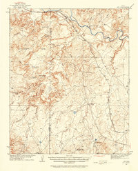
1934 Map of Ady
USGS Topo · Published 1968About this map
The Canadian River carves a deep valley through this portion of Potter and Oldham Counties, defining a landscape of complex drainage systems and isolated cattle ranching outposts. During the early 1930s, the region was characterized by its vast ranch holdings and the vital transit corridor of the Fort Worth and Denver City RR, which runs parallel to the Fort Worth and Denver Highway in the north. Named ranch sites like L S Ranch, Vanetta Ranch, and Tecovas Spring (Fryingpan Ranch) reflect the local livestock economy, while the presence of Hereford Well and Rock Canyon Well highlight the critical importance of water access in the high plains. Significant topographic landmarks, such as the broken terrain of Five Fingers and the prominent Rotten Hill, sit between deep-cut canyons like Rock Canyon and Goodman Canyon, illustrating the erosional power of the river's tributaries.
Find a feature on this map
37 named features on this map. Tap any name to fly to it.
Don’t see what you’re looking for? This feature index may not catch every label — zoom into the map to look around manually.
Map Details
Editions of this 1934 Ady Map
2 editions found
Other maps of this area

1934 · Ady
USGS Topo · 1:62,500

1934 · Cliffside
USGS Topo · 1:62,500

1936 · Fourways
USGS Topo · 1:62,500

1936 · Cliffside
USGS Topo · 1:62,500

1936 · Ady
USGS Topo · 1:62,500

1953 · Marsh
USGS Topo · 1:24,000

1953 · Puente
USGS Topo · 1:24,000

1953 · Cliffside
USGS Topo · 1:24,000

1954 · Tucumcari
USGS Topo · 1:250,000

1954 · Amarillo
USGS Topo · 1:250,000