2021 Map of Afton
USGS Topo · Published 2021About this map
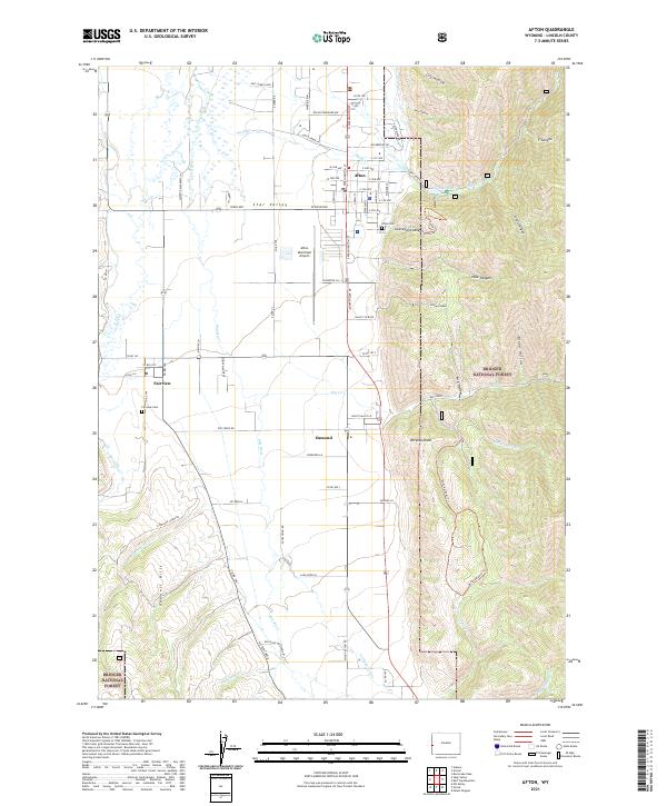
Star Valley serves as the central pastoral corridor of this map, where the Salt River meanders through agricultural lands between the high peaks of the Bridger National Forest and the Gannett Hills. In the town of Afton, the residential grid is clearly defined by landmarks such as the Afton Municipal Airport and the Afton Cem. The landscape reflects a well-established irrigation and ranching community, with the smaller settlements of Fairview and Osmond anchoring the valley floor. Water management is a primary feature of the local geography, evidenced by the numerous canyons and drainages feeding into the valley, including Swift Cr which descends from Swift Cr Lake through the steep terrain of Graveyard Canyon. The map records a dense network of local roads and family-named avenues, such as Rulon Gardener Ave, illustrating the transition from the organized town center to the expansive valley rangelands.
Find a feature on this map
91 named features on this map. Tap any name to fly to it.
Don’t see what you’re looking for? This feature index may not catch every label — zoom into the map to look around manually.
Map Details
Editions of this 2021 Afton Map
This is the sole edition of this map. No revisions or reprints were ever made.
Historical Maps of Afton Through Time
4 maps found