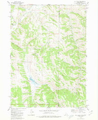
1980 Map of Elk Valley
USGS Topo · Published 1980About this map
Gannett Hills dominate the terrain of this high-country survey along the Idaho-Wyoming border, where the Caribou National Forest meets the Bridger National Forest. The landscape is defined by a dense network of watercourses including Sage Creek, Crow Creek, and a series of numbered drainages from First Spring Creek to Sixth Creek. This area was primarily utilized for resource management and backcountry transit, evidenced by the numerous pack trails and jeep trails that navigate the ridges between landmarks like The Pinnacle and Clover Knoll. A single Drill Hole and a label for a Driveway near the southern boundary represent the few signs of human development in this remote mountainous region, which straddles Caribou, Lincoln, and Bear Lake counties.
Find a feature on this map
32 named features on this map. Tap any name to fly to it.
Don’t see what you’re looking for? This feature index may not catch every label — zoom into the map to look around manually.
Map Details
Editions of this 1980 Elk Valley Map
2 editions found
Other maps of this area

1909 · Montpelier
USGS Topo · 1:125,000

1911 · Montpelier
USGS Topo · 1:125,000

1915 · Crow Creek
USGS Topo · 1:62,500

1921 · Afton
USGS Topo · 1:125,000

1936 · Cokeville
USGS Topo · 1:96,000

1942 · Cokeville
USGS Topo · 1:125,000

1949 · Stewart Flat
USGS Topo · 1:24,000

1949 · Snowdrift Mountain
USGS Topo · 1:24,000

1951 · Stewart Flat
USGS Topo · 1:24,000
1951 · Snowdrift Mountain
USGS Topo · 1:24,000