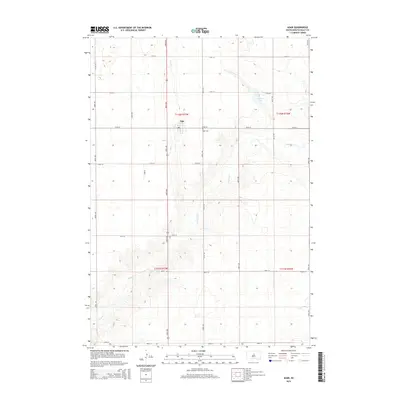
2015 Map of Agar
USGS Topo · Published 2015About this map
Agar serves as the central hub for this portion of Sully County, situated at the intersection of 176th St and 304th Ave. This agricultural settlement is defined by a rigid grid of section lines and county roads, including 302nd Ave and 182nd St, which divide the landscape into organized townships like t116n r77w. The local topography is carved by the winding path of Okobojo Cr, which flows through the southern and eastern reaches of the area, providing a natural contrast to the geometric precision of the surrounding farmland. To the east of the town center, Agar Cem and the small waters of Mundt Lake provide quiet landmarks for genealogists and local historians tracing the heritage of this High Plains community. The map illustrates a rural economy built on large-scale land management, with clearly delineated boundaries between townships and ranges.
Find a feature on this map
23 named features on this map. Tap any name to fly to it.
Don’t see what you’re looking for? This feature index may not catch every label — zoom into the map to look around manually.
Map Details
Editions of this 2015 Agar Map
This is the sole edition of this map. No revisions or reprints were ever made.
Other maps of this area

1953 · Huron
USGS Topo · 1:250,000

1954 · Pierre
USGS Topo · 1:250,000

1954 · Huron
USGS Topo · 1:250,000

1958 · Pierre
USGS Topo · 1:250,000

1965 · Agar SW
USGS Topo · 1:24,000

1965 · Agar
USGS Topo · 1:24,000

1965 · Sully Lake
USGS Topo · 1:24,000
1967 · Blunt NW
USGS Topo · 1:24,000

1970 · Agar NW
USGS Topo · 1:24,000
1970 · Agar NE
USGS Topo · 1:24,000