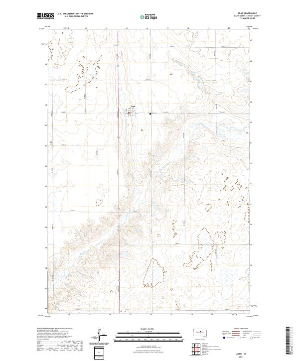
2021 Map of Agar
USGS Topo · Published 2021About this map
The small settlement of Agar sits at the center of this Sully County landscape, defined by a rigid grid of section roads and the winding path of Okobojo Cr. This high plains geography is marked by the presence of Agar Cem just east of the village on Agar Rd, a focal point for local genealogical research. To the northeast, the depression of Mundt Lake breaks the pattern of agricultural fields. The township boundaries, including t116n r77w and t115n r76w, organize a region where transportation is dictated by numbered avenues such as 304th Ave and 305th Ave, which serve as the primary conduits between the scattered homesteads and the central community. The detailed mapping of small water bodies and seasonal drainage highlights the environmental challenges of this prairie environment during the early 21st century.
Find a feature on this map
24 named features on this map. Tap any name to fly to it.
Don’t see what you’re looking for? This feature index may not catch every label — zoom into the map to look around manually.
Map Details
Editions of this 2021 Agar Map
This is the sole edition of this map. No revisions or reprints were ever made.
Other maps of this area

1953 · Huron
USGS Topo · 1:250,000

1954 · Pierre
USGS Topo · 1:250,000

1954 · Huron
USGS Topo · 1:250,000

1958 · Pierre
USGS Topo · 1:250,000

1965 · Agar SW
USGS Topo · 1:24,000

1965 · Agar
USGS Topo · 1:24,000

1965 · Sully Lake
USGS Topo · 1:24,000
1967 · Blunt NW
USGS Topo · 1:24,000

1970 · Agar NW
USGS Topo · 1:24,000
1970 · Agar NE
USGS Topo · 1:24,000